Grand Island in Erie County, New York — The American Northeast (Mid-Atlantic)
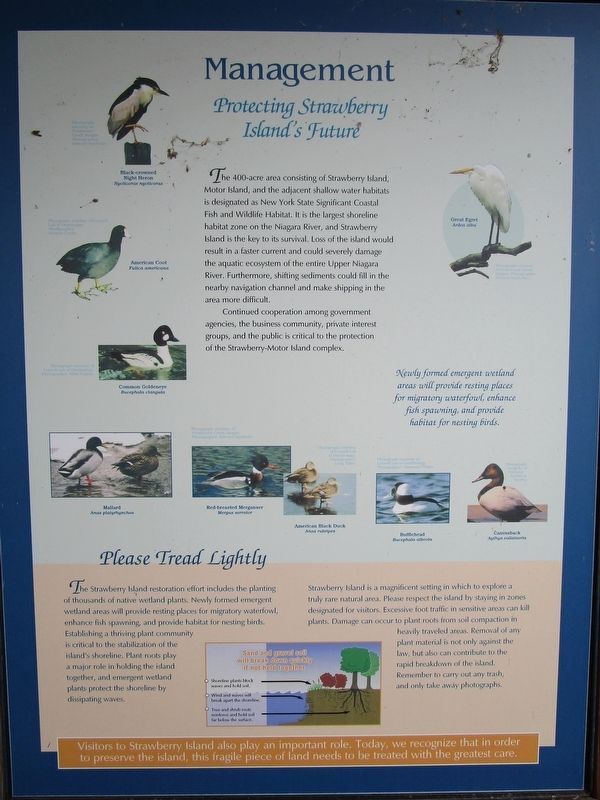
Management
Protecting Strawberry Island's Future
Continued cooperation among government agencies, the business community, private interest groups, and the public is critical to the protection of the Stawberry-Motor Island complex.
Newly formed emergent wetland areas will provide resting places for migratory waterfowl, enhance fish spawning, and provide habitat for nesting birds.
[captions:] Black-crowned Night Heron, Nycticorax nycticorax. Photograph courtesy of Freshwater Creek images. Photographer Edward Sambolin.
American Coot, Fulica americana. Photograph courtesy of Cornell Lab of Ornithology. Photographer Herbert Clarke.
Common Goldeneye, Bucephala clangula. Photograph courtesy of Cornell Lab of Ornithology. Photographer Mike Hopiak.
Mallard, Anas platyrhynchos.
Red-breasted Merganser, Mergus serrator. Photograph courtesy of Freshwater Creek images. Photographer Edward Sambolin.
American Black Duck, Anas rubripes. Photograph courtesy of Cornell Lab of Ornithology. Photographer Lang Elliot.
Bufflehead, Bucephala albeola. Photograph courtesy of Cornell Lab of Ornithology. Photographer Lawrence Wales.
Canvasback, Aythya valisineria. Photograph courtesy of National Audubon Society.
Great Egret, Ardea alba. Photograph courtesy of Freshwater Creek images. Photographer Edward Sambolin.
Please Tread Lightly
The Strawberry Island restoration effort includes the planting of thousands of native wetland plants. Newly formed emergent wetland areas will provide resting places for migratory waterfowl, enhance fish spawning, and provide habitat for nesting birds. Establishing a thriving plant community is critical to the stabilization of the island's shoreline. Plant roots play a major role in holding the island together, and emergent wetland plants protect the shoreline by dissipating waves.
Strawberry Island is a magnificant setting in which to explore a truly rare natural area. Please respect the island by staying in zones designated for visitors. Excessive foot traffic in sensitive areas can kill plants. Damage can occur to plant roots from soil compaction in heavily traveled areas. Removal of any plant material is not only against the
law, but can also contribute to the rapid breakdown of the island. Remember to carry out any trash, and only take away photographs.
[inset:] Sand and gravel soil will break down quickly if not held together. • Shoreline plants block waves and hold soil. • Wind and waves will break apart the shoreline. • Tree and shrub roots reinforce and hold soil far below the surface.
Visitors to Strawberry Island also play an important role. Today we recognize that in order to preserve the island, this fragile piece of land needs to be treated with the greatest care.
Topics. This historical marker is listed in these topic lists: Animals • Environment.
Location. 42° 57.551′ N, 78° 56.329′ W. Marker is on Grand Island, New York, in Erie County. Marker is on Park Road Loop at Area 3, on the right when traveling east. Marker is along the park road loop past area 3 in Beaver Island State Park. Touch for map. Marker is in this post office area: Grand Island NY 14072, United States of America. Touch for directions.
Other nearby markers. At least 8 other markers are within walking distance of this marker. Recovery (here, next to this marker); Strawberry Island (here, next to this marker); Did You Ever Wonder What It Takes to Restore an Island? (here, next to this marker); a different marker also named Strawberry Island (here, next to this marker); A Home for Fish (here, next to this marker); Island Life (here, next to this marker); Allenton Farm/Creating Beaver Island State Park (approx. 0.2 miles away); Grover Cleveland & Grand Island / Lewis F. Allen & Western New York (approx. 0.2 miles away). Touch for a list and map of all markers in Grand Island.
Also see . . . Beaver Island - New York State Office of Parks, Recreation & Historic Preservation. Vehicle entrance fee collected in season. (Submitted on January 28, 2017, by Anton Schwarzmueller of Wilson, New York.)
Credits. This page was last revised on January 28, 2017. It was originally submitted on January 28, 2017, by Anton Schwarzmueller of Wilson, New York. This page has been viewed 282 times since then and 7 times this year. Photos: 1, 2. submitted on January 28, 2017, by Anton Schwarzmueller of Wilson, New York.

