Near Townsend in New Castle County, Delaware — The American Northeast (Mid-Atlantic)
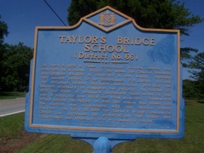
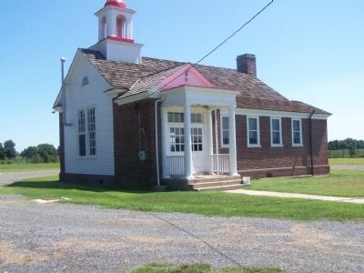
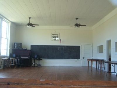
Taylor's Bridge School
(District No. 66)
Erected 1997 by Delaware Public Archives. (Marker Number NC-93.)
Topics and series. This historical marker is listed in this topic list: Education. In addition, it is included in the Delaware Public Archives series list. A significant historical month for this entry is April 1907.
Location. 39° 24.329′ N, 75° 35.318′ W. Marker is near Townsend, Delaware, in New Castle County. Marker is on Fleming Landing Rd., 0.1 miles south of Taylor Bridge Road, on the left when traveling south. Touch for map. Marker is in this post office area: Townsend DE 19734, United States of America. Touch for directions.
Other nearby markers. At least 8 other markers are within 6 miles of this marker, measured as the crow flies. Duncan Beard (approx. 3.8 miles away); Old Union Methodist Church (approx. 4.1 miles away); Scott Church (approx. 4.6 miles away); Blackbird School (District No. 69) (approx. 4.6 miles away); The Corbit-Sharp House (approx. 5 miles away); The Tatman Office (approx. 5.1 miles away); Veterans Memorial (approx. 5.1 miles away); Old St. Paul's Church (approx. 5.3 miles away). Touch for a list and map of all markers in Townsend.
Additional commentary.
1. Smyrna Times news article from April 11, 1923
Storm hits Taylors Bridge doing considerable damage, attains cyclonic force as it demolishes houses and auto
School House Blown From Its Foundation - Porch Torn from Elmer Davids Residence - Crops Hurt
A terrific storm swept the State Thursday afternoon (April 5, 1923), tearing up trees and telephone poles damaging crops, flooding roads and in some parts of the State demolishing whole houses. Smyrna escaped any material damage although the rain came in a veritable deluge with some high wind, but over in Thoroughfare Neck it was another story. A veritable cyclone struck Taylor's Bridge. Two automobiles passing through the town had their tops blown off before they could reach shelter. The high wind was accompanied by a driving rain, making it almost impossible to see. The car of Nathaniel Van Horn, which was parked along the road, was almost wrecked.
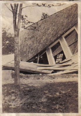
Miss Gladys McBooker, teacher of the Taylor's Bridge school, who was about to leave the school with three little children, stopped in the vestibule, not daring to venture out in the storm. Feeling the building tremble, she became frightened and ran with the children out into the field. Looking back a moment later she saw the schoolhouse torn from its foundations and carried aloft by the wind. Part of the building was jammed against a tree and the other part was blown over into a field. It is said the tree is what saved the teacher and pupils being carried with it.
The garage of James McClain was shattered by the cyclone. The house of Elmer David, nearby, also fell a victim to the storm and was almost demolished, the porch being torn off. Apple trees were torn up by the roots in some places. The storm lasted 20 minutes. Some of the wreckage was blown as far as Cedar Swamp, behind the town. Although Taylor's Bridge was the place hardest hit, other towns in the district experienced high winds and heavy rainfall. In the vicinity of Middletown limbs of many trees were torn off by the wind. The district northwest of Wilmington as far as Kennett Square was also hard hit by the storm. Five telephone poles and wire for the distance of a half mile were torn down between Kennett Square and Mendenhall. The Diamond State Telephone Company was at work throughout the night repairing the damage.
— Submitted July 28, 2009, by Ernie Mabrey of Philadelphia, Pennsylvania.

Photographed By Ernie Mabrey, April 5, 1923
4. Old Taylor's Bridge School
This photo is from an old family album. I've always been told that it is of the old Taylor's Bridge School that was destroyed in the April 5, 1923 storm mentioned on the marker. My great-grandparents lived at the Taylor's Bridge lighthouse, which was a stone's throw from the old school, so I am inclined to believe this is a photo of that school.
Credits. This page was last revised on November 9, 2019. It was originally submitted on August 22, 2008, by Bill Pfingsten of Bel Air, Maryland. This page has been viewed 3,284 times since then and 72 times this year. Photos: 1, 2, 3. submitted on August 22, 2008, by Bill Pfingsten of Bel Air, Maryland. 4. submitted on July 28, 2009, by Ernie Mabrey of Philadelphia, Pennsylvania.


