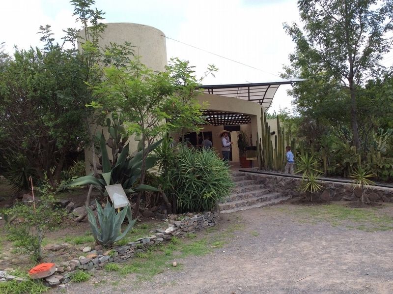
El Pueblito in La Corregidora, Querétaro, Mexico — The Central Highlands (North America)
El Cerrito ("The Little Hill")
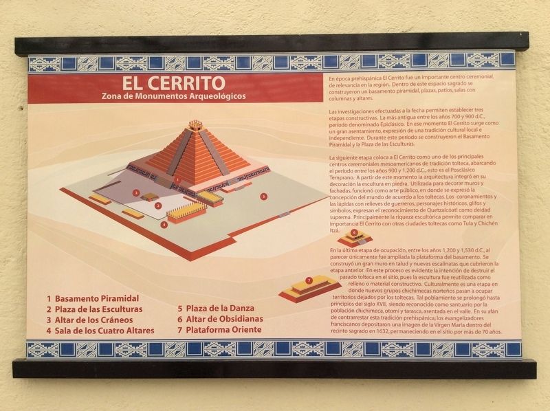
Zona de Monumentos Arqueológicos
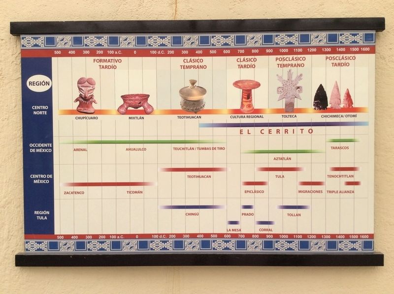
Las investigaciones efectuadas a la fecha permiten establecer tres etapas constructivas. La más antigua entre los anos 700 y 900 d.C., período denominado Epiclásico. En ese momento El Cerrito surge como un gran asentamiento, expresión de una tradición cultural local e independiente. Durante este período se construyeron el Basamento Piramidal y la Plaza de las Esculturas.
La siguiente etapa coloca a El Cerrito como uno de los principales centros ceremoniales mesoamericanos de tradición tolteca, abarcando el período entre los años 900 y 1,200 d.C, esto es el Posclásico Temprano. A partir de este momento la arquitectura integró en su decoración la escultura en piedra. Utilizada para decorar muros y fachadas, funcionó como arte público, en donde se expresó la concepción del mundo de acuerdo a los toltecas. Los coronamientos y las lápidas con relieves de guerreros, personajes históricos, glifos y símbolos, expresan el reconocimiento de Quetzalcóatl como deidad suprema. Principalmente la riqueza escultórica permite comparar en importancia El Cerrito con otras ciudades toltecas como Tula y Chichén Itzá.
En la última etapa de ocupación, entre los años 1,200 y 1,530 d.C., al parecer únicamente fue ampliada la plataforma del basamemento. Se construyó un gran muro en talud y nuevas escalinatas que cubrieron la etapa anterior. En este proceso es evidente la intención de destruir el pasado tolteca en el sitio, pues la escultura fue reutilizada como relleno o material constructivo. Culturalmente es una etapa en donde nuevos grupos chichimecas norteños pasan a ocupar territorios dejados por los toltecas. Tal poblamiento se prolongó hasta principios del siglo XVII, siendo reconocido como santuario por población chichimeca, otomí y tarasca, asentada en el valle. En su afán de contrarrestar esta tradición prehispánica, los evangelizadores franciscanos depositaron una imagen de la Virgen María dentro del recinto sagrado en 1632, permaneciendo en el sitio por más de 70 años.
Leyenda:
1 Basamento Piramidal
2 Plaza de las Esculturas
3 Altar de los Cráneos
4 Sala de los Cuatro Altares
5 Plaza de la Danza
6 Altar de Obsidianas
7 Plataforma Oriente
English translation:
Archaeological Monuments Area
Within this sacred space were built a pyramid on a large base, plazas, courtyards, rooms with columns and altars.
The investigations carried out to date establish three construction periods. The oldest period was between 700 and 900 AD and this period is called the Pre-Classic. At that time El Cerrito emerged as a great settlement as an expression of a localized and independent cultural tradition. During this period the Pyramid and the Plaza of Sculptures were built.
The next stage places El Cerrito as one of the main Mesoamerican ceremonial centers of the Toltec tradition, spanning the period between 900 and 1200 AD. This is the Early Postclassic period. From this moment the architecture of the site began to integrate the use of stone sculptures into its decoration, using them to decorate walls and facades. These sculptures functioned as a type of public art, where the conception of the world according to the Toltecs was expressed. The crowning sculptural elements and tombstones included reliefs of warriors, historical figures, glyphs and symbols, all expressing the recognition of Quetzalcoatl as a supreme deity. The sculptural richness seen here allows a comparison of El Cerrito with other Toltec cities like Tula and Chichén Itzá.
In the last period of occupation, between the years 1200 and 1530, the platform of the base of the pyramid was expanded.
Photographed By J. Makali Bruton, March 3, 2019
3. An additional nearby El Cerrito Marker
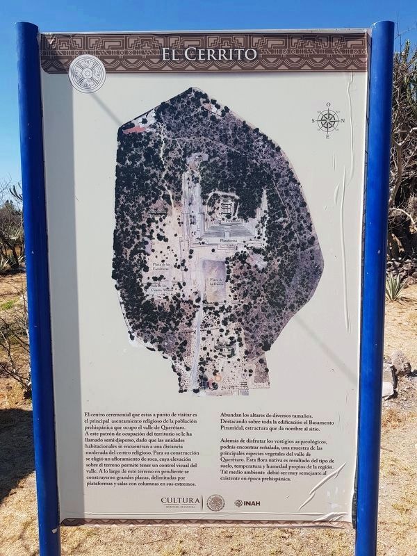
This additional marker and map is near the beginning of the path up to the site's pyramid. It reads:
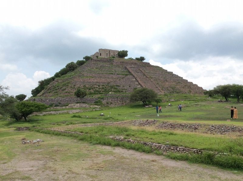
El Cerrito El centro ceremonial que estas a punto de visitar es el principal asentamiento religioso de la población prehispánica que ocupo el valle de Querétaro. A este patrón de ocupación del territorio se le ha llamado semi disperso, dado que la unidades habitacionales se encuentran a una distancia moderada del centro religioso. Para su construcción se eligió un afloramiento de roca, cuya elevación sobre el terreno permite tener un control visual del valle. A lo largo de este terreno en pendiente se construyeron grandes plazas, delimitadas por plataformas y salas con columnas en sus extremos. Abundan los altares de diversos tamaños. Destacando sobre toda la edificación el Basamento Piramidal, estructura que da nombre al sitio.
Además de disfrutar los vestigios arqueológicos, podrás encontrar señalada, una muestra de las principales especies vegetales del valle de Querétaro. Esta flora nativa es resultado del tipo de suelo, temperatura y humedad propios de la región. Tal medio ambiente debió ser muy semejante al existente en época prehispánica.
English translation:
El Cerrito The ceremonial center you are about to visit is the main religious settlement of the pre-Hispanic population that occupied the Querétaro Valley. This pattern of occupation of the territory has been called semi-dispersed, given that the housing units are at a moderate distance from the religious center. For its construction an outcrop of rock was chosen, whose elevation above the ground allowed the inhabitants to control the valley. Large squares were built along this sloping terrain, delimited by platforms and rooms with columns at their ends. Altars of different sizes abound. The main Pyramid is outstanding and gives the site its name.
Besides enjoying the archaeological remains, you can find a sample of the main plant species of the Queretaro Valley here. This native flora is the result of the type of soil, temperature and humidity typical of the region. Such an environment must have been very similar to that existing in pre-Hispanic times.
Además de disfrutar los vestigios arqueológicos, podrás encontrar señalada, una muestra de las principales especies vegetales del valle de Querétaro. Esta flora nativa es resultado del tipo de suelo, temperatura y humedad propios de la región. Tal medio ambiente debió ser muy semejante al existente en época prehispánica.
El Cerrito The ceremonial center you are about to visit is the main religious settlement of the pre-Hispanic population that occupied the Querétaro Valley. This pattern of occupation of the territory has been called semi-dispersed, given that the housing units are at a moderate distance from the religious center. For its construction an outcrop of rock was chosen, whose elevation above the ground allowed the inhabitants to control the valley. Large squares were built along this sloping terrain, delimited by platforms and rooms with columns at their ends. Altars of different sizes abound. The main Pyramid is outstanding and gives the site its name.
Besides enjoying the archaeological remains, you can find a sample of the main plant species of the Queretaro Valley here. This native flora is the result of the type of soil, temperature and humidity typical of the region. Such an environment must have been very similar to that existing in pre-Hispanic times.
Legend:
1 Pyramid and base
2 Plaza of the Sculptures
3 Altar of the Skulls
4 Room of the Four Altars
5 Plaza of the Dances
6 Altar of Obsidian
7 Eastern Platform
Topics. This historical marker is listed in these topic lists: Anthropology & Archaeology • Architecture • Man-Made Features • Native Americans. A significant historical year for this entry is 700 CE.
Location. 20° 33.051′ N, 100° 26.488′ W. Marker is in El Pueblito, Querétaro, in La Corregidora. Marker can be reached
from Calle Miguel Hidalgo just north of Camino al Cerrito, on the left when traveling north. The marker is located at the entrance to the El Cerrito Archaeological Site, directly after entering the site by foot from the parking area. Touch for map. Marker is in this post office area: El Pueblito QUE 76915, Mexico. Touch for directions.
Other nearby markers. At least 8 other markers are within walking distance of this marker. Obsidian Altar (within shouting distance of this marker); The Earth and its Cosmic Paths (about 90 meters away, measured in a direct line); The Building of the Four Altars (about 150 meters away); The Plaza of the Sculptures (about 150 meters away); The Plaza of the Dancers (about 150 meters away); Platform and Pyramid (about 210 meters away); The "Little Fort" (about 210 meters away); The Altar of the Skulls (approx. 0.2 kilometers away). Touch for a list and map of all markers in El Pueblito.
Credits. This page was last revised on May 14, 2019. It was originally submitted on July 24, 2017, by J. Makali Bruton of Accra, Ghana. This page has been viewed 222 times since then and 18 times this year. Photos: 1, 2. submitted on July 24, 2017, by J. Makali Bruton of Accra, Ghana. 3. submitted on May 14, 2019, by J. Makali Bruton of Accra, Ghana. 4, 5, 6. submitted on July 24, 2017, by J. Makali Bruton of Accra, Ghana.
