Corolla in Currituck County, North Carolina — The American South (South Atlantic)
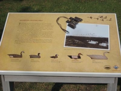
Waterfowl Resting Area
In the past the number of waterfowl attracted here each winter soared to great numbers. This caused a phenomenon referred to locally as "smoke." So many ducks and geese filled the sky they formed a dark cloud that blocked the sun. Although changes in water quality have reduced the numbers of waterfowl, many types of birds still rest in area waters.
These photographs show a selection of decoys owned by the Whalehead Preservation Trust and displayed at the Outer Banks Center for Wildlife Education. They represent wildfowl common to the area.
[Text with upper right photo:] Binoculars. Courtesy of the Currituck Wildlife Guild
[Text with middle right photo:] Birds in flight over the Currituck Outer Banks.
[Text with decoys, left to right:]
Canada Goose. Canada Goose decoy made by Ned Burgess, ca. 1930.
Coot. Coot decoy made by Ellie Saunders, ca. 1925.
Ruddy Duck. Ruddy Duck decoy made by John Williams, ca. 1885.
Canvas Back. Canvas Back decoy made by Callie O'Neal, ca. 1945.
Swan. Swan decoy made by Mannie Haywood, ca. 1935.
Erected by Whalehead Club Currituck Heritage Park, Outer Banks Center for Wildlife Education, N.C. Wildlife Resources Commission.
Topics. This historical marker is listed in these topic lists: Animals • Native Americans • Waterways & Vessels. A significant historical year for this entry is 1930.
Location. 36° 22.441′ N, 75° 49.999′ W. Marker is in Corolla, North Carolina, in Currituck County. Marker can be reached from the intersection of Ocean Trail (State Highway 12) and Club Road. Marker is within Whalehead Park, past the bridge, about a 1/4 mile west from the entrance to the park. Touch for map. Marker is in this post office area: Corolla NC 27927, United States of America. Touch for directions.
Other nearby markers. At least 8 other markers are within walking distance of this marker. Corolla Island Bridges (a few steps from this marker); Duck Blinds (within shouting distance of this marker); Waterfowl Hunting (within shouting distance of this marker); The Whalehead Club (about 300 feet away, measured in a direct line); The Whalehead Club Restoration (about 400 feet away); Ray T. Adam's Landing Strip (about 500 feet away); A Nation's Defense (about 500 feet away); First Swimming Pool on the Outer Banks (about 600 feet away). Touch for a list and map of all markers in Corolla.
Credits. This page was last revised on June 16, 2016. It was originally submitted on August 25, 2008, by F. Robby of Baltimore, Maryland. This page has been viewed 1,461 times since then and 15 times this year. Photos: 1, 2. submitted on August 25, 2008, by F. Robby of Baltimore, Maryland.

