Pulaski in Oswego County, New York — The American Northeast (Mid-Atlantic)
Salmon River
Heh-Hah-Walter-Gah (where swim the sweet fish – Iroquois)
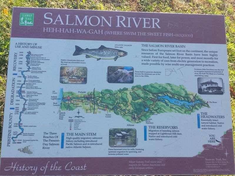
2000 1998 First return of adult Atlantic Salmon.
1997 Natural reproduction of Chinook Salmon documented.
1996 Minimum flow standards established.
1995 Atlantic Salmon re-introduced.
1980 Salmon River Hatchery built.
1976 Chemical contaminents discovered in fish.
1968 Pacific salmon stocking initiated.
1930 Power generation overshadows fishery.
1926 Rainbow Trout introduced.
1914 Dam built to form Salmon River Reservoir.
1900 1898 Atlantic Salmon extinct in Lake Ontario.
1869 Eight dams block the river.
1864 First record of sport fishing.
1836 Commercial fishing peaks.
1801 1800 First permanent settlement.
1788-1776 U.S. gains control of area from British.
1700 1684 British control area.
1672 1657 Jesuits document salmon resource.
1615 1600 Europeans explore the rver.
The Salmon River Basin
Since before Europeans set foot on the continent, the unique resources of the Salmon River Basin have been highly valued. First for food, later for power, and most recently for a wide variety of uses from electric generation to recreation, made possible by wise multi-use management practices.
The Three Reaches Of The Present-Day Salmon River
The Main Stem
High quality migratory salmonid fishery including introduced Pacific Salmon and re-introduced native Atlantic Salmon.
The Reservoirs
Migration of breeding salmon stopped at Lighthouse Hill dam. Native and introduced cold water fishery.
The Headwaters
Essentially intact natural habitat. Native and introduced cold water fishery.
History of the Coast
Major Seaway Trail rivers were magnets for Native Americans and eatly European settlers.
Topics and series. This historical marker is listed in these topic lists: Environment • Waterways & Vessels. In addition, it is included in the Great Lakes Seaway Trail National Scenic Byway series list.
Location. 43° 34.241′ N, 76° 11.214′ W. Marker is in Pulaski, New York, in Oswego County. Marker is at the intersection of New York State Route 3 and Riverside Drive, on the right when traveling south on State Route 3. Touch for map. Marker is in this post office area: Pulaski NY 13142, United States of America. Touch for directions.
Other nearby markers. At least 8 other markers are within 3 miles of this marker, measured as the crow flies. Selkirk Lighthouse (approx. 0.8 miles away); Pulaski Court House (approx. 2.9 miles away); Pulaski Revolutionary Heroes Memorial (approx. 2.9 miles away); Richland and Pulaski Civil War Soldiers Monument (approx. 2.9 miles away); Casimir Pulaski (approx. 3 miles away); Richland World War I Monument (approx. 3 miles away); Pioneer Settlers (approx. 3 miles away); Pulaski Historic District (approx. 3 miles away). Touch for a list and map of all markers in Pulaski.
Also see . . .
1. The Seaway Trail. (Submitted on October 21, 2017, by Michael Herrick of Southbury, Connecticut.)
2. Salmon River (New York) on Wikipedia. (Submitted on October 21, 2017, by Michael Herrick of Southbury, Connecticut.)
Credits. This page was last revised on October 21, 2017. It was originally submitted on October 21, 2017, by Michael Herrick of Southbury, Connecticut. This page has been viewed 303 times since then and 23 times this year. Photos: 1, 2, 3, 4. submitted on October 21, 2017, by Michael Herrick of Southbury, Connecticut.


