Near Addison in Addison County, Vermont — The American Northeast (New England)
Canada Geese
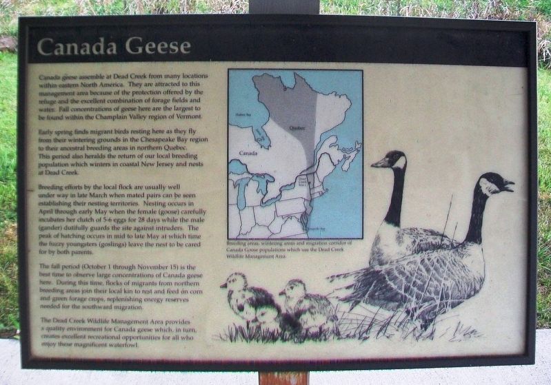
Canada geese assemble at Dead Creek from many locations within eastern North America. They are attracted to this management area because of the protection offered by the refuge and the excellent combination of forage fields and water. Fall concentrations of geese here are the largest to be found within the Champlain Valley region of Vermont.
Early spring finds migrant birds resting here as they fly from their wintering grounds in the Chesapeake Bay region to their ancestral breeding areas in northern Quebec. This period also heralds the return of our local breeding population which winters in coastal New Jersey and nests at Dead Creek.
Breeding efforts by the local flock are usually well under way in late March when mated pairs can be seen establishing their nesting territories. Nesting occurs in April through early May when the female (goose) carefully incubates her clutch of 5-6 eggs for 28 days while the male (gander) dutifully guards the site against intruders. The peak of hatching occurs in mid to late May at which time the fuzzy youngsters (goslings) leave the nest to be cared for by both parents.
The fall period (October 1 through November 15) is the best time to observe large concentrations of Canada geese here. During this time, flocks of migrants from northern breeding areas join their local kin to rest and feed on corn and green forage crops, replenishing energy reserves needed for the southward migration.
The Dead Creek Wildlife Management Area provides a quality environment for Canada geese which, in turn, creates excellent recreational opportunities for all who enjoy these magnificent waterfowl.
Erected by Vermont Fish & Wildlife Department.
Topics. This historical marker is listed in these topic lists: Animals • Environment • Waterways & Vessels.
Location. 44° 5.115′ N, 73° 20.207′ W. Marker is near Addison, Vermont, in Addison County. Marker is on Vermont Route 17W, 1.7 miles west of Vermont Route 22A, on the left when traveling west. Markers are under a shelter at the roadside wildlife viewing area. Touch for map. Marker is at or near this postal address: 2015 Vermont Route 17W, Vergennes VT 05491, United States of America. Touch for directions.
Other nearby markers. At least 8 other markers are within 6 miles of this marker, measured as the crow flies. Wetland Resources (here, next to this marker); Snow Geese (here, next to this marker); The Dead Creek Wildlife Management Area (here, next to this marker); War Memorial (approx. 1.7 miles away); Benedict Arnold (approx. 4.1 miles away); DAR John Strong Mansion (approx. 4.3 miles away); Northern Terminal of the Crown Point Military Road (approx. 5.3 miles away); Chimney Point (approx. 5.4 miles away). Touch for a list and map of all markers in Addison.
Additional commentary.
1. About the inclusion of this sign in the database
At the time this signage was filed, these types of signs were included in HMdb.org. However, the guidelines have since been tightened and similar signs are no longer admitted.
— Submitted March 19, 2024, by Devry Becker Jones of Washington, District of Columbia.
Credits. This page was last revised on March 19, 2024. It was originally submitted on October 26, 2017, by William Fischer, Jr. of Scranton, Pennsylvania. This page has been viewed 238 times since then and 20 times this year. Photos: 1, 2, 3, 4. submitted on October 26, 2017, by William Fischer, Jr. of Scranton, Pennsylvania.


