Rogue River in Jackson County, Oregon — The American West (Northwest)
Rising above the Rogue

Photographed By Barry Swackhamer, September 21, 2017
1. Rising above the Rogue Marker
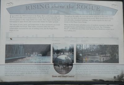
aptions: (above photographs) Flood level timeline; (center left) Depot Street Bridge during the 1964 flood.; (middle) The flood of 1964; (center right) At over twenty-five feet, the 1997 flood filled Coyote Evans Wayside.; (bottom) Dams and Flood Control: Floods, though natural occurrences, can have devastating effects on towns and communities, Dams serve as buffers agains rising water. Excess runoff is captured behind the dam and is released slowly - protecting downstream areas. To help protect the City of Rogue River, Congress approved The Flood Control Act of 1962, authorizing dams of local rivers. As a result, to nearby dams were completed - the William L. Jess Dam at Lost Creel and the Applegate Dam on the Applegate River. The Jess and Applegate dams have prevented millions of dollars in damages throughout their years of service. But even these control measures can't completely prevent floods. In 1997, runoff exceeded the capacity of the local dams and excess water was released - swelling the river above flood stage. Counties work to minimize the flood damage by creating flood zones, diverting high water around developed areas, and enforcing building codes designed to keep buildings above high water.
The whims of rain, snow, and temperature in these mountains can create unpredictable river levels. That winter, excessive rains and warm temperatures increased the rate of melting snow, and the Rogue River began to rise.
Throughout the night, the river rose and by 4:00 am on December 23, it was four feet above the previous flood record. Water poured down streets and sidewalks, inundated buildings, and crashed against the deck and trusses of the Depot Street Bridge.
When the floodwaters subsided, scores of residents returned to find badly damaged homes and businesses swamped with mud. The "Christmas Flood" of 1964 was one of the worst Rogue River floods on record, but it was nothing new.
Erected by City of Rogue River.
Topics. This historical marker is listed in these topic lists: Bridges & Viaducts • Disasters • Man-Made Features. A significant historical date for this entry is December 22, 1964.
Location. 42° 25.862′ N, 123° 10.313′ W. Marker is in Rogue River, Oregon, in Jackson County. Marker is on Rogue River Highway (Oregon Route 99) near North Star Lane, on the right when traveling west. Touch for map. Marker is at or near this postal address: 8898 Rogue River Highway, Rogue River OR 97537, United States of America. Touch for directions.
Other nearby markers. At least 8 other markers are within 4 miles of this marker, measured as the crow flies. A Bridge for a New Century (here, next to this marker); Crossing the Rogue (here, next to this marker); The City of Rogue River (here, next to this marker); Evan's Ferry (a few steps from this marker); Applegate Trail - Fort Birdseye (approx. 2 miles away); Fort Birdseye (approx. 2 miles away); Valley of the Rogue Applegate Trail Kiosk (approx. 2.6 miles away); Rock Point, Oregon (approx. 4.1 miles away). Touch for a list and map of all markers in Rogue River.
More about this marker. This marker is near the Rogue River Chamber of Commerce.
Credits. This page was last revised on January 26, 2018. It was originally submitted on January 15, 2018, by Barry Swackhamer of Brentwood, California. This page has been viewed 269 times since then and 11 times this year. Photos: 1, 2. submitted on January 15, 2018, by Barry Swackhamer of Brentwood, California.
