Memphis in Shelby County, Tennessee — The American South (East South Central)
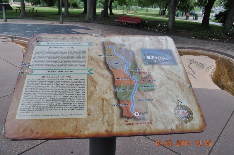
Plaquemine, Louisiana/Manchac Bend
Panel #16 Mississippi Riverwalk
Inscription.
A) Plaquemine, Louisiana
Mile 208.2 AHP
The settlement that arose at the mouth of the Bayou Plaquemine took as its name the Native American word for the fruit, persimmon. Early settlers traveled on the bayou, but as the Mississippi River rounded Plaquemine Bend, it poured into the open bayou mouth. This mouth was later closed to prevent flooding. Plaquemine surrender quietly to Union forces during the Civil War, but Confederate gorillas were sporadically active in this area. Disaster struck in 1880 when the town’s riverfront washed away in a massive bank cave in. In 1908, the Corps of Engineers built a navigation lock at the mouth of the bayou to allow shipping to move from the Mississippi River through Bayou Plaquemine to the Intercoastal Waterway. The lock became obsolete and is now closed. Long a trade center for the area’s sugar and lumber, Plaquemine is now involved in the booming petrochemical industry.
B) Manchac Bend
Mile 215.5 AHP
The Bayou Manchac, running east from this bend was a major landmark in the early years of river exploration. French explorer, Iberville traveled here in 1699 hoping to discover a shortcut to his outpost on the Gulf of Mexico, but he found the bayou impassable. The French named the bayou in his honor, but later settlers used its original Native American name, Manchac. In 1763, it became the boundary between the British colony to the north and the Spanish colony to the south. The British built Fort Bute at the river junction and cleared the bayou as a shipping channel to the Gun of Mexico. Men were stationed at the bayou’s entrance to keep out driftwood and floating debris. In 1779, Don Bernardo de Galves, the governor of Spanish Louisiana, captured the fort from the British and claimed all of British West Florida for Spain. After the U. S. Took possession of the area, Bayou Manchac was closed to prevent the British from sneaking up the Mississippi River during the war of 1812. Later, local planters damned the bayou’s mouth to stop the flooding of their lands during times of high water. Today Bayou Manchac is permanently closed by the Mainline Levee System.
Photo Credit: The Lockhouse at Plaquemine Lock State Park/Louisiana Office of Tourism
Erected by Mississippi Riverwalk. (Marker Number 16.)
Topics. This historical marker is listed in these topic lists: Native Americans • Settlements & Settlers • War, US Civil • Waterways & Vessels.
Location. 35° 8.968′ N, 90° 3.518′ W. Marker is in Memphis, Tennessee, in Shelby County. Marker can be reached from Island Drive, 0.8 miles south of West A.W. Willis Avenue. Located in Mud Island River Park. Touch for map. Marker is at or near this postal address: 125 N Front St, Memphis TN 38103, United States of America. Touch for directions.
Other nearby markers. At least 8 other markers are within walking distance of this marker. The Mississippi Riverwalk (a few steps from this marker); Island No. 20/Cottonwood Point/Booth Point, Tennessee/Linwood Bend (a few steps from this marker); Head of Passes/Pilottown, Louisiana (a few steps from this marker); Venice Louisiana/Fort Jackson, Louisiana/Fort St. Phillip (a few steps from this marker); Ostrica Lock/Buras, Louisiana/Empire Lock/Nairn, Louisiana (a few steps from this marker); Point a La Hache, Louisiana/Magnolia Plantation, Louisiana (a few steps from this marker); Junior Crevasse/Poverty Point, Louisiana/Jesuits Bend (a few steps from this marker); Belle Chasse, Louisiana/English Turn Bend/Caernarvon Crevasse/Poydras Crevasse (a few steps from this marker). Touch for a list and map of all markers in Memphis.
Also see . . .
1. Plaquemines Parish, Louisiana. The name "Plaquemines," in French Creole, was derived from the Atakapa word, piakimin, meaning the local fruit persimmon. The French used it to name a military post they built on the banks of the Mississippi River, as the site was surrounded by numerous persimmon trees. Eventually the name was applied to the entire parish and to a nearby bayou. (Submitted on March 14, 2018, by Sandra Hughes Tidwell of Killen, Alabama, USA.)
2. Manchac, Louisiana. Fort Bute or Manchac Post, named after the then British Prime Minister John Stuart, 3rd Earl of Bute, was established in 1763 at the junction of Iberville River (Bayou Manchac) with the Mississippi River, and remained an important military and trading post in British West Florida until captured by Spanish forces under Bernardo Galvez of Louisiana (New Spain) on September 7, 1779, during what became known as Battle of Fort Bute of the American Revolutionary War. Manchac was raided in February 1778 by American forces under the command of James Willing[1]—see related articles, Continental Marines and USS Morris. Fort Bute/Manchac Post/Mississippi River at Bayou Manchac is 45 miles from Manchac. (Submitted on March 14, 2018, by Sandra Hughes Tidwell of Killen, Alabama, USA.)
3. Why Maps?. Fort Plaquemine, Plaquemine, La. is in slide 24 with many old Plaquemine pictures and levee failures. The is the only, known by me, drawing of Fort Plaquemine. (Submitted on April 4, 2018, by Kenneth Ramagost of Unknown, Louisiana.)
Credits. This page was last revised on April 4, 2018. It was originally submitted on March 14, 2018, by Sandra Hughes Tidwell of Killen, Alabama, USA. This page has been viewed 337 times since then and 32 times this year. Photo 1. submitted on March 14, 2018, by Sandra Hughes Tidwell of Killen, Alabama, USA. • Bernard Fisher was the editor who published this page.
Editor’s want-list for this marker. Wide shot of marker and its surroundings. • Can you help?
