Potomac West in Alexandria, Virginia — The American South (Mid-Atlantic)
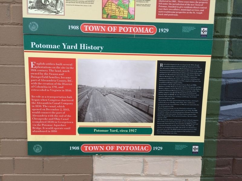
Potomac Yard History
Town of Potomac
— 1908 - 1929 —
English settlers built several plantations on the site in the 18th century. The land, much owned by the Swann and Daingerfield families, became part of Alexandria County, D.C. with the creation of the District of Columbia in 1791, and retroceded to Virginia in 1846.
Its role as a transportation hub began when Congress chartered the Alexandria Canal Company in 1830. The canal, which opened on December 2, 1843, would connect the port of Alexandria with the end of the Chesapeake and Ohio Canal (completed 1850) in Georgetown via the Potomac Aqueduct Bridge. It would operate until abandoned in 1886
(photo caption)
Potomac Yard, circa 1917
Railroad development in the area began in the 1850s, though stymied by political concerns and by the American Civil War. The Alexandria and Washington Railroad began service on a new rail line between Long Bridge and Alexandria in 1857. Order to the region's mishmash of active and abandoned rail lines and stations did not come until the City Beautiful movement of the late 19th century. The 1901 Plan for Washington, D.C. (report of the McMillan Commission) proposed consolidating the region's rail operations, including a new Washington Union Station (approved 1903, completed 1908) and a New Long Railroad Bridge (completed 1904).
In accordance with the plan, the Pennsylvania Railroad (PRR), Baltimore and Ohio Railroad, Southern Railway, Chesapeake and Ohio Railway, Atlantic Coast Line Railroad, and Seaboard Air Line Railway formed the Richmond-Washington Company to manage traffic. This holding company controlled the Richmond, Fredericksburg and Potomac Railroad (RF&P), the new Alexandria Union Station, which opened in 1905, and the new switching yard—Potomac Yard—which opened on October 15, 1906.
The booming "Pot Yard" attracted thousands of workers, who largely settled in the areas of Del Ray and St. Elmo. These subdivisions incorporated as the town of Potomac in 1908, but were annexed by the City of Alexandria in 1930.
Potomac Yard in its heyday was one of the busiest railyards in the Eastern United States, processing thousands of cars daily. The PRR extended its railway electrification program to Potomac Yard in 1935, marking its southernmost point. The Penn Central segment of the famous Tropicana Juice Train operated from here. The site reached capacity in 1937.
After the corporate mergers of the former separate railroad companies that used the yard to interchange freight cars, the need for Potomac Yard greatly diminished. It was determined by the RF&P that the land was worth more than the need for yard switching. The PRR's old catenary was dismantled in the 1980s. The facility was identified
Produced for the Town of Potomac Centennial in 2008 by the City of Alexandria. research and text by Leland Ness
Erected 2008 by City of Alexandria, Virginia.
Topics and series. This historical marker is listed in these topic lists: Bridges & Viaducts • Railroads & Streetcars • Settlements & Settlers • Waterways & Vessels. In addition, it is included in the Virginia, The City of Alexandria series list. A significant historical date for this entry is October 15, 1906.
Location. 38° 49.636′ N, 77° 3.523′ W. Marker is in Alexandria, Virginia. It is in Potomac West. Marker is on Mount Vernon Avenue south of East Uhler Avenue, on the right when traveling north. Touch for map. Marker is at or near this postal address: 2525 Mount Vernon Avenue, Alexandria VA 22301, United States of America. Touch for directions.
Other nearby markers. At least 8 other markers are within walking distance of this marker. St. Asaph Racetrack (here, next to this marker); Universal Lodge No. 1 (within shouting distance of this marker); The Town of Potomac / Mount Vernon Avenue (within shouting distance of this marker); Schools in the Town of Potomac (about 400 feet away, measured in a direct line); The Electric Railway (about 600 feet away); a different marker also named St. Asaph Racetrack (about 700 feet away); Corporal Charles William Hill (about 700 feet away); Captain Rocky Versace Plaza and Vietnam Veterans Memorial (about 700 feet away). Touch for a list and map of all markers in Alexandria.
Credits. This page was last revised on January 27, 2023. It was originally submitted on March 17, 2018, by Devry Becker Jones of Washington, District of Columbia. This page has been viewed 425 times since then and 70 times this year. Photos: 1, 2. submitted on March 17, 2018, by Devry Becker Jones of Washington, District of Columbia. • Bernard Fisher was the editor who published this page.

