Bethesda in Montgomery County, Maryland — The American Northeast (Mid-Atlantic)
From Trolley to Trail: A Brief History
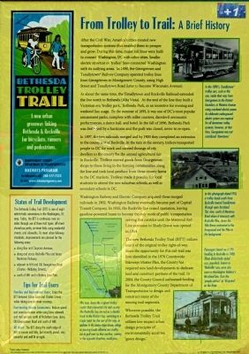
After the Civil War, America's cities created new transportation systems that enabled them to prosper and grow. During this time, major rail lines were built to connect Washington, D.C. with other cities. Smaller electric streetcar or 'trolley' lines connected Washington with its outlying areas. In 1890, the Georgetown and Tenallyetown Railway Company operated trolley lines from Georgetown to Montgomery County, using High Street and Tennallytown Road. (later to become Wisconsin Avenue).
At about the same time, the Tenallytown and Rockville Railroad extended the line north to Bethesda (Alta Vista). At the end of the line they built a Victorian era 'Trolley park,' Bethesda Park, as an incentive for evening and weekend usage. By summer 1893, it was one of DC's most popular amusement parks, complete with roller coasters, daredevil aeronautic performances, a dance hall, an hotel. In the fall of 1896, Bethesda Park was destroyed by a hurricane and the park was closed, never to re-open.
In 1897, the two railroads merged and by 1900 they completed an extension to the county seat of Rockville. At the turn of the century, trolleys transported people to DC for work and carried throngs of city dwellers to the county for the annual agricultural fair in Rockville. Trolleys moved goods from Georgetown shops to those living in farming communities along the line and took local produce from these country farms to DC markets. Trolleys made it possible for local students to attend the new suburban schools, as well as secondary schools in DC.
Washington Railway and Electric Company acquired these merged railroads in 1902. Washington Railway eventually became part of the Capital Transit Company. In 1935, the Rockville line ceased operation, leaving gasoline-powered buses to become the only mode of public transportation serving this corridor until the Metrorail Red Line extension to Shady Grove was opened in 1984.
The new Bethesda Trolley Trail (BTT) utilizes much of the original trolley right-of-way. Since the opportunity for this rail-trail was first identified in the 1978 Countywide Bikeways Master Plan, the County has required new land developments to dedicate land and construct portions of the trail. In 2004, the County Council authorized funding for the Montgomery Department of Transportation to design and construct many of the missing segments.
Wherever possible, the Bethesda Trolley Trail utilizes low-impact urban design principles of environmentally 'green design.'
[Captions:]
This map shows the original trolley routes that connected city and county. The Rockville line started as a double track to the District line, switching to a single track for the rest of the way. In addition to the station stops shown, sidings or passing tracks allowed one trolley car to pull over so that another, coming in the opposite direction, could pass.
In the 1890's, Tenallytown* trolley cars, such as this one, made their way from Georgetown to the District boundary at Western Avenue using overhead electric power. An elaborate underground electric system was required for all downtown trolley systems; however, at that time, Georgetown was not considered 'downtown.'
In this photograph dated 1910, a trolley heads south from Rockville toward Tenallytown through open farmland. This view, south of Montrose Road where it intersects with Rockville Pike, shows the Villa Roma restaurant in the foreground and the Pike in the background.
Passengers board car # 596 heading to Rockville in 1908. These distinctively styled cars, particularly known as 'Rockville' cars, were used on Washington Railway's Maryland line. Note the 'people catcher' or 'lifeguard' on the front.
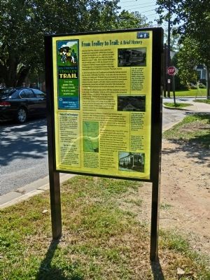
Erected by Montgomery County Department of Transportation.
Topics. This historical marker is listed in this topic list: Railroads & Streetcars. A significant historical year for this entry is 1890.
Location. 38° 59.462′ N, 77° 6.025′ W. Marker is in Bethesda , Maryland, in Montgomery County. Marker can be reached from the intersection of Glenbrook Road and Rugby Avenue. Touch for map. Marker is at or near this postal address: 8102 Glenbrook Road, Bethesda MD 20814, United States of America. Touch for directions.
Other nearby markers. At least 8 other markers are within walking distance of this marker. Veterans Memorial (approx. ¼ mile away); Tennallytown and Rockville Railroad (approx. 0.3 miles away); Tree I (approx. 0.3 miles away); Old Georgetown Road (approx. 0.3 miles away); Locust Grove (approx. 0.3 miles away); This Complex of Buildings and Gardens (approx. 0.3 miles away); Bear and the Steelhead (approx. 0.4 miles away); a different marker also named Old Georgetown Road (approx. 0.4 miles away). Touch for a list and map of all markers in Bethesda.
Credits. This page was last revised on April 7, 2023. It was originally submitted on December 13, 2012, by Allen C. Browne of Silver Spring, Maryland. This page has been viewed 734 times since then and 16 times this year. Last updated on April 24, 2018, by Devry Becker Jones of Washington, District of Columbia. Photos: 1, 2. submitted on December 13, 2012, by Allen C. Browne of Silver Spring, Maryland. • Andrew Ruppenstein was the editor who published this page.

