Palmyra in Wayne County, New York — The American Northeast (Mid-Atlantic)
Towpath and Aqueduct / Father of the Iron Bridge
Towpath and Aqueduct
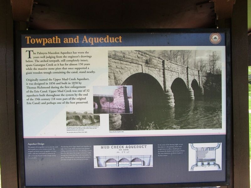
The Palmyra-Macedon Aqueduct has worn the years well judging from the engineer's drawings below. The arched towpath, still completely intact, spans Ganargua Creek as it has for almost 150 years while the massive stone piers that once supported a giant wooden trough containing the canal, stand nearby.
Originally named the Upper Mud Creek Aqueduct, it was designed in 1856 and built in 1858 by Thomas Richmond during the first enlargement of the Erie Canal. Upper Mud Creek was one of 32 aqueducts built throughout the system by the end of the 19th century (18 were part of the original Erie Canal) and perhaps one of the best preserved.
[captions] The aqueduct's stone piers support a wooden trough (shown in this photo at the Rome Aqueduct), in the early part of chis century. (Notice the water leaking from between the wooden seams). The stone piers today near Palmyra (inset, right). Palmyra Aqueduct today.
Aqueduct Design
The purpose of an aqueduct was to carry the canal and towpath over a river, ravine, or road. The towpath was borne across an aqueduct on stone arches, while the canal itself was carried in an adjacent heavily-braced wooden trough restong on stone piles.
The drawing of the Upper Mud Creek Aqueduct at right, dates to the 1850s and shows the aqueduct looking north down the river. The drawing, viewed from the side, shows the trough (in brown), visible through the twenty-four foot wide arches (in gray). the abutments, curving out at the corners, provided strength for the structure at its ends.
In the center of the drawing (right, as seen from above), is the planking of the canal trough shown in yellow. (shaded gray at the bottom for shadow) and resting on beams. The stone abutments are shown in gray at the four corners.
Father of the Iron Bridge
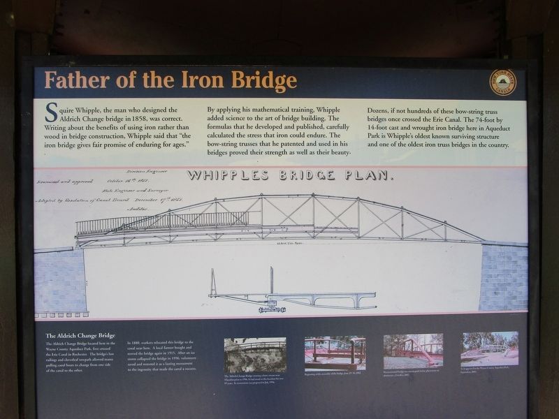
Squire Whipple, the man who designed the Aldrich Change Bridge in 1858, was correct. Writing about the benfits of using iron rather than wood in bridge constrction, Whipple said that, "the iron bridge gives fair promise of enduring for ages."
By applying his mathematical training, Whipple added science to the art of bridge building. The formulas that he developed and published, carefully calculated the stress that iron could endure. The bow-string trusses that he patented and used in his bridges proved their strength as well as their beauty.
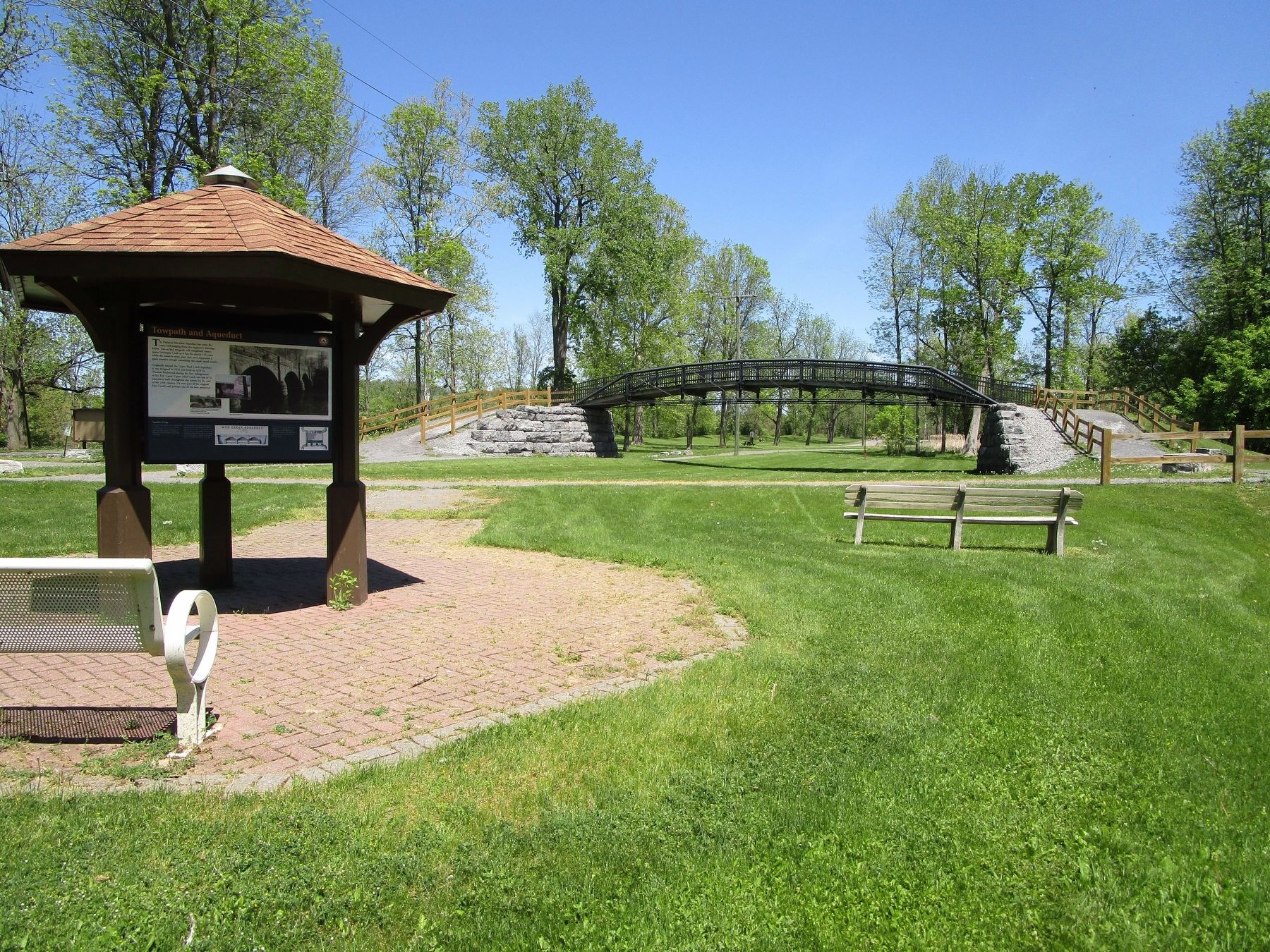
Dozens, if not hundreds of these bow-string truss bridges once crossed the Erie Canal. The 74-foot by 14-foot cast and wrought iron bridge here in Aqueduct Park is Whipple's oldest known surviving structure and one of the oldest truss bridges in the country.
The Aldrich Change Bridge
The Aldrich Change Bridge located here in the Wayne County Aqueduct Park, first crossed the Erie Canal in Rochester. The bridge's low railings and cloverleaf towpath allowed teams to pass from one side of the canal to the other.
In 1880, workers relocated this bridge to the canal near here. A local farmer bought and moved the bridge again in 1915. After an ice storm collapsed the bridge in 1996, volunteers saved and restored it as a lasting monument to the ingenuity that made the canal a success.
[captions] The Aldrich Change Bridge crossing a farm stream near Macedon prior to 1996. It has stood at this location for over 85 years. Its restoration was proposed in July, 1996. Beginning asssembly of the bridge, June 29-30, 2002. Reconstructed bridge on cement pads before placement on abutments, October, 2002. As it appeared in the Wayne County Aqueduct Park, September, 2003.
Erected by New York State Canals.
Topics and series. This historical marker is listed in these topic lists: Bridges & Viaducts • Man-Made Features • Waterways & Vessels. In addition, it is included in the Erie Canal series list. A significant historical date for this entry is June 29, 2002.
Location. 43° 3.836′ N, 77° 14.864′ W. Marker is in Palmyra, New York, in Wayne County. Marker can be reached from West Main Street (New York State Route 31) 0.1 miles north of Creek Road. Marker is in Pal-Mac Aqueduct Park, a county park so-named because the park stradles the towns of Palmyra and Macedon. Touch for map. Marker is at or near this postal address: 555 West Main Street, Palmyra NY 14522, United States of America. Touch for directions.
Other nearby markers. At least 8 other markers are within walking distance of this marker. Historic Sites (approx. 0.6 miles away); Cumorah (approx. 0.7 miles away); First Church (approx. 0.7 miles away); First School House (approx. 0.7 miles away); World War I Mortar (approx. 0.8 miles away); Admiral William T. Sampson Memorial (approx. 0.8 miles away); Palmyra War Memorial (approx. 0.8 miles away); May 29, 1800 (approx. 0.8 miles away). Touch for a list and map of all markers in Palmyra.
Credits. This page was last revised on May 22, 2018. It was originally submitted on May 22, 2018, by Anton Schwarzmueller of Wilson, New York. This page has been viewed 586 times since then and 65 times this year. Photos: 1, 2, 3, 4. submitted on May 22, 2018, by Anton Schwarzmueller of Wilson, New York.


