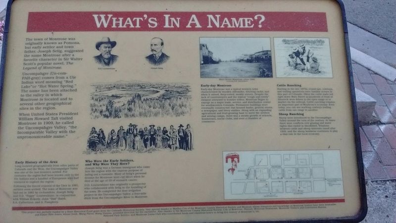
Montrose in Montrose County, Colorado — The American Mountains (Southwest)
What's in a Name?
Uncompahgre (Un-com-PAH-gray) comes from a Ute Indian word meaning "Red Lake" or "Hot Water Spring". The name has been attached to the valley in which Montrose is located and to several other geographical sites in the region.
When United States President William Howard Taft visited Montrose in 1909, he called the Uncompahgre Valley, "the Incomparable Valley with the unpronounceable name."
Early History of the Area
Long isolated geographically from other parts of Colorado and the West, the Uncompahgre Valley was one of the last frontiers settled. For centuries the region had been known only to the Ute Indians and a handful of Europeans who had ventured to explore the region.
Following the forced removal of the Utes in 1881, settlers soon arrived. The town of Montrose was laid-out in 1882 by co-founders, Joseph Selig and O.D. "Pappy" Loutsenhizer, in conjunction with William Eckerly, John "Dad" Baird, S.A. Culbertson, and A. Pumphrey.
Who Were the Early Settlers. and Why Were They Here?
Joseph Selig was a German immigrant who came into the region with the express purpose of laying out a townsite. Many of Selig's personal dreams for Montrose were cut short when he died at the age of 39 of stomach cancer.
O.D. Loutsenhizer was originally a prospector who collaborated with Selig in the founding of the town. He completed the first irrigation project in the Uncompahgre Valley, a four-mile ditch from the Uncompahgre River to Montrose.
Early-day Montrose
Early-day Montrose was a typical western town characterized by wooden sidewalks, hitching racks, and when it rained, deep-rutted, muddy streets. Despite the lack of conveniences and the typical "rough and rowdy" element attracted to frontier towns, Montrose began to emerge as a major trade, service, and distribution center for southwestern Colorado. Permanent buildings were eventually constructed that housed banks, general stores, a newspaper, and livery stables. Along with an expanding agricultural and fruit-growing base to serve the settlers and mining camps, there was a steady
Cattle Ranching
Starting in the late 1870s, round-ups, cowboys and trailing operations were familiar scenes in this part of Colorado. Often the cattle trails led right down Main Street as hundreds of head of livestock were driven to the open range or to market via the railroad. Cattle ranching remains an important part of Montrose's economy. Even today, you can see working cowboys trailing cattle from one range to another.
Sheep Ranching
Sheep were introduced to the Uncompahgre Valley around the turn of the century. At times there were conflicts over grazing and water rights that ended in bloodshed. Tensions between cattle and sheep interests eased after 1920, and the sheep business continues to play a vital role in the local economy.
Erected by Colorado Historical Society.
Topics and series. This historical marker is listed in this topic list: Settlements & Settlers. In addition, it is included in the Colorado - Montrose - Preserving Our Heritage, and the Former U.S. Presidents: #27 William Howard Taft series lists. A significant historical year for this entry is 1909.
Location. 38° 28.767′ N, 107° 52.617′ W. Marker is in Montrose, Colorado, in Montrose County. Marker is at the intersection of East Main Street and Cascade Avenue, on the left when traveling east on East Main Street. Touch for map. Marker is in this post office area: Montrose CO 81401, United States of America. Touch for directions.
Other nearby markers. At least 8 other markers are within walking distance of this marker. Preserving Our Heritage (within shouting distance of this marker); a different marker also named Preserving Our Heritage (within shouting distance of this marker); a different marker also named Preserving Our Heritage (within shouting distance of this marker); a different marker also named Preserving Our Heritage (about 400 feet away, measured in a direct line); The Gunnison Tunnel (about 400 feet away); The Winds of Change (about 600 feet away); Veterans Memorial (about 600 feet away); Instrument of Surrender (about 600 feet away). Touch for a list and map of all markers in Montrose.
Also see . . .
1. City of Montrose History. The first settlers came to the Uncompahgre Valley in the 1870s, but legally could not purchase land until after September 1881, when the Ute Indians were removed from their land and put on a reservation in Utah. (Submitted on July 14, 2018, by Tom Bosse of Jefferson City, Tennessee.)
2. History of Montrose. Montrose was chartered in 1882 by people from places east, who wanted a place to succeed as ranchers and farmers. Its location in the middle of the Uncompahgre Valley was only complicated by the Ute Nation people who wintered there until being removed just prior to the city being established. (Submitted on July 14, 2018, by Tom Bosse of Jefferson City, Tennessee.)
Credits. This page was last revised on July 17, 2018. It was originally submitted on July 14, 2018, by Tom Bosse of Jefferson City, Tennessee. This page has been viewed 281 times since then and 29 times this year. Photo 1. submitted on July 14, 2018, by Tom Bosse of Jefferson City, Tennessee. • Syd Whittle was the editor who published this page.
Editor’s want-list for this marker. Wide area view of the marker and its surroundings. • Can you help?
