Bolivar in Jefferson County, West Virginia — The American South (Appalachia)
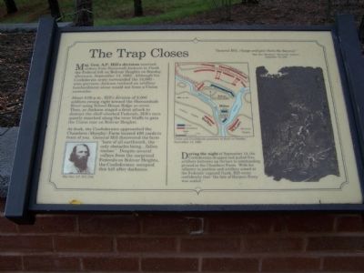
The Trap Closes
"General Hill, charge and give them the bayonet."
Major Gen. Thomas J. "Stonewall" Jackson
September 15, 1862
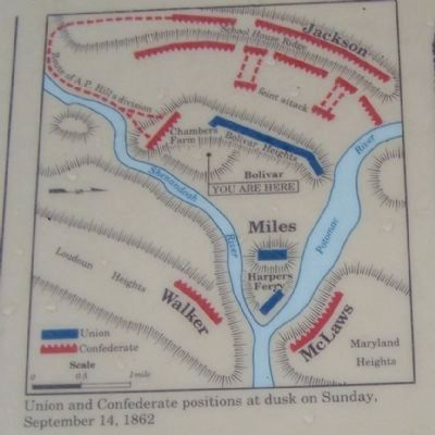
Maj. Gen. A. P. Hill's division received orders from Stonewall Jackson to flank the Federal left on Bolivar Heights on Sunday afternoon, September 14, 1862. Although his Confederate army surrounded the 14,000 - man garrison. Jackson realized an artillery bombardment alone would not force a Union surrender.
About 4:00 p.m., Hill's division of 3,000 soldiers sung right toward the Shenandoah River using School House Ridge as cover. Then, as Jackson staged a feint attack to distract the shell-shocked Federals, Hill's men quietly marched along the river bluffs to gain the Union rear on Bolivar Heights.
At dusk, the Confederates approached the Chambers (Murphy) Farm located 400 yards in front of you. General Hill discovered the farm "bare of all earthwork, the only obstacles being...fallen timber." Despite several volleys from the surprises Federals on Bolivar Heights, the Confederates occupied this hill after darkness.
During the night of September 14, the Confederates dragged and pulled five artillery batteries up ravines to commanding ground at the Chambers Farm. With his infantry in position and artillery aimed at the Federals' exposed flank, Hill wrote confidently that "the fate of Harpers Ferry was sealed."
Topics. This historical marker is listed in this topic list: War, US Civil. A significant historical month for this entry is September 1863.
Location. 39° 18.995′ N, 77° 45.43′ W. Marker is in Bolivar, West Virginia, in Jefferson County. Marker can be reached from Shenandoah St.. Located at the visitor center in Harpers Ferry National Historic Site. Touch for map. Marker is in this post office area: Harpers Ferry WV 25425, United States of America. Touch for directions.
Other nearby markers. At least 8 other markers are within walking distance of this marker. Confederate Victory (a few steps from this marker); Discover Harpers Ferry (a few steps from this marker); Harpers Ferry National Historical Park (within shouting distance of this marker); A Union Predicament (within shouting distance of this marker); History in the Mountains (within shouting distance of this marker); Jackson at Harpers Ferry (approx. ¼ mile away); Home Becomes Battlefield (approx. 0.3 miles away); From Civil War to Civil Rights / Battle of Harpers Ferry (approx. 0.4 miles away). Touch for a list and map of all markers in Bolivar.
Credits. This page was last revised on June 5, 2020. It was originally submitted on October 4, 2008, by Bill Pfingsten of Bel Air, Maryland. This page has been viewed 942 times since then and 14 times this year. Photos: 1, 2. submitted on October 4, 2008, by Bill Pfingsten of Bel Air, Maryland. 3. submitted on May 14, 2009, by Craig Swain of Leesburg, Virginia.


