Derry Township near Hershey in Dauphin County, Pennsylvania — The American Northeast (Mid-Atlantic)
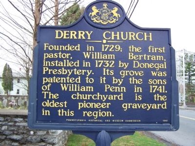
Derry Church
American Presbyterian and Reformed Historical Site
Erected 1947 by Pennsylvania Historical and Museum Commission.
Topics and series. This historical marker is listed in these topic lists: Cemeteries & Burial Sites • Churches & Religion • Colonial Era. In addition, it is included in the American Presbyterian and Reformed Historic Sites, and the Pennsylvania Historical and Museum Commission series lists. A significant historical year for this entry is 1729.
Location. 40° 17.524′ N, 76° 38.744′ W. Marker is near Hershey, Pennsylvania, in Dauphin County. It is in Derry Township. Marker is on East Derry Road, on the left when traveling west. Touch for map. Marker is at or near this postal address: 221 E Derry Rd, Hershey PA 17033, United States of America. Touch for directions.
Other nearby markers. At least 8 other markers are within walking distance of this marker. Derry Session House and Enclosure (within shouting distance of this marker); Derry Church School (1844-1904) (about 700 feet away, measured in a direct line); Hershey (approx. 0.3 miles away); Derry Churchyard (approx. 0.3 miles away); a different marker also named Hershey (approx. 0.4 miles away); Chocolate Workers' Sit-Down Strike (approx. half a mile away); Wilt Chamberlain's Scoring Record (approx. 0.6 miles away); The Four Seasons Statues (approx. 0.6 miles away). Touch for a list and map of all markers in Hershey.
Regarding Derry Church. Derry Presbyterian Church is one of 445 American Presbyterian and Reformed Historical Sites registered between 1973 and 2003 by the Presbyterian Historical Society (PHS), headquartered in Philadelphia. Approved sites received a metal plaque featuring John Calvin’s seal and the site’s registry number (PHS marker location unknown).
The following text is taken from the Presbyterian Historical Society website:
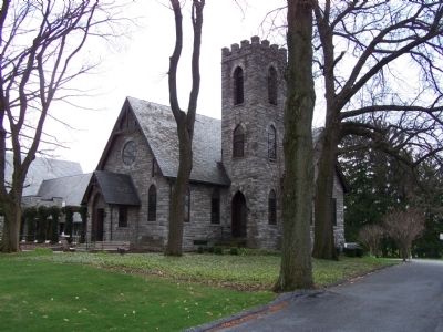
Derry Presbyterian Church was organized in 1729. William Penn's sons deeded the land to the congregation in 1741. The present sanctuary, a stone church with stained glass windows, was erected in 1884. The congregation’s oldest structure, and the oldest surviving building in the Hershey area, is the Session House, or Pastor’s Study. Built in 1732 of hand-hewn logs and heated by a stone fireplace, it also served as an academy for the children of early settlers. The study even served for a time as the post office of the village of “Derry Church,” which became the town of Hershey. In 1929, Mr. S.M. Hershey, the chocolate maker, provided funds to build a protective glass enclosure for the study.
Related marker. Click here for another marker that is related to this marker. To better understand the relationship, study each marker in the order shown.
Also see . . . MarkerQuest - Derry Church and Churchyard. Further information about the history of Derry Church. (Submitted on December 4, 2018, by Laura Klotz of Northampton, Pennsylvania.)
Credits. This page was last revised on February 7, 2023. It was originally submitted on April 16, 2008, by Bill Pfingsten of Bel Air, Maryland. This page has been viewed 2,133 times since then and 162 times this year. Last updated on August 24, 2018, by Douglass Halvorsen of Klamath Falls, Oregon. Photos: 1, 2. submitted on April 16, 2008, by Bill Pfingsten of Bel Air, Maryland.

