Lolo in Missoula County, Montana — The American West (Mountains)
The Lolo Trail
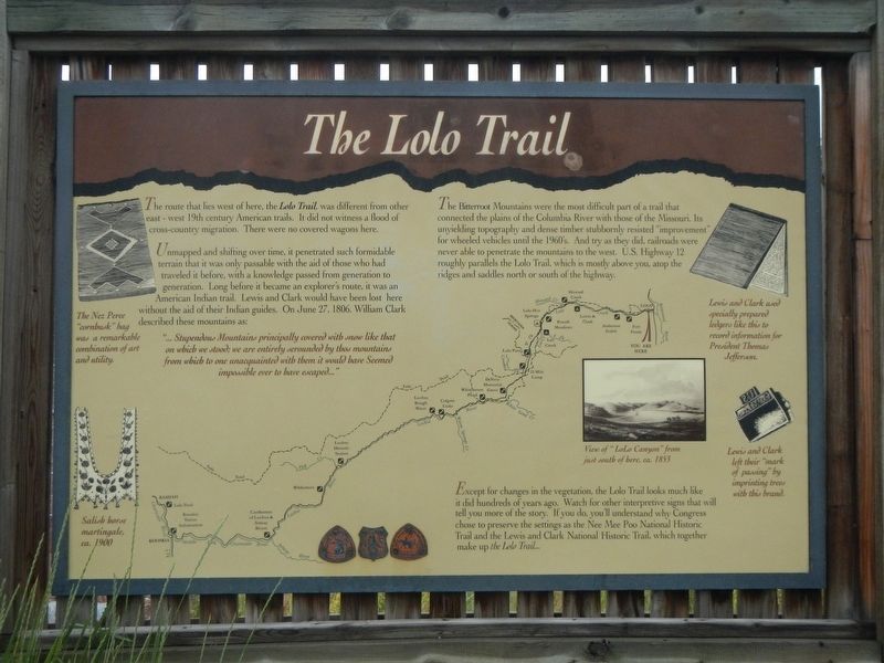
Unmapped and shifting over time, it penetrated such formidable terrain that it was only passable with the aid of those who had traveled it before, with a knowledge passed from generation to generation. Long before it became an explorer's route, it was an American Indian trail. Lewis and Clark would have been lost here without the aide of their Indian guides. On June 27, 1806, William Clark described these mountains as:
"... Stupendous Mountains principally covered with snow like that on which we stood; we are entirely serounded by thos mountains from which to one unacquainted with them it would have Seemed impossible ever to have escaped..."
The Bitterroot Mountains were the most difficult part of a trail that connected the plains of the Columbia River with those of the Missouri. Its unyielding topography and dense timber stubbornly resisted "improvement" for wheeled vehicles until the 1960's. And try they did, railroads were never able to penetrate the mountains to the west. U.S. Highway 12 roughly parallels the Lolo Trail, which is mostly above you, atop the ridges and saddles north or south of the highway.
Except for changes in the vegetation, the Lolo Trail looks much like it did hundred of years ago. Watch for other interpretive signs that will tell you more of the story. If you do, you'll understand why Congress chose to preserve the settings as the Nee Mee Poo National Historic Trail and the Lewis and Clark National Historic Trail, which together make up the Lolo Trail...
Erected by U.S. Forest Service.
Topics and series. This historical marker is listed in these topic lists: Exploration • Native Americans • Roads & Vehicles. In addition, it is included in the Lewis & Clark Expedition series list. A significant historical date for this entry is June 27, 1806.
Location. 46° 45.415′ N, 114° 5.112′ W. Marker is in Lolo, Montana, in Missoula County. Marker is on Lolo Creek Road (Highway 12) near U.S. 93, on the right when traveling east. Touch for map. Marker is at or near this postal address: 6560 Lolo Creek Road, Lolo MT 59847, United States of America. Touch for directions.
Other nearby markers. At least 8 other markers are within 5 miles of this marker, measured as the crow flies. Travellers Rest (approx. 0.3 miles away); A Crossroads of Culture (approx. 0.4 miles away); The Journey Home (approx. half a mile away); Uncovering the Expedition (approx. half a mile away); Following Formation (approx. half a mile away); Lewis and Clark in Salish Territory (approx. 1.1 miles away); Bitterroot Valley, Homeland of the Selíš (approx. 1.1 miles away); Lewis and Clark on Lolo Creek (approx. 4.2 miles away). Touch for a list and map of all markers in Lolo.
Also see . . . Lewis and Clark: The Lolo Trail -- National Park Service. Ever a dim track through a primeval land, this rugged trail across the backbone of the Bitterroot Mountains is still essentially in wilderness country and is little changed from the days when the Lewis and Clark Expedition passed over it both en route to and returning from the Pacific. Since long before that time, the Nez Perce Indians had been traversing the trail annually as they passed back and forth from their homeland along the Clearwater River in north-central Idaho to their buffalo hunting grounds in Montana. And in 1877, during the Nez Perce War, the nontreaty faction of the tribe, pursued by Gen. Oliver O. Howard's troops, utilized the route in its epic retreat from Idaho into Montana. (Submitted on September 10, 2018, by Barry Swackhamer of Brentwood, California.)
Credits. This page was last revised on September 10, 2018. It was originally submitted on September 10, 2018, by Barry Swackhamer of Brentwood, California. This page has been viewed 229 times since then and 21 times this year. Photos: 1, 2. submitted on September 10, 2018, by Barry Swackhamer of Brentwood, California.

