Joppatowne in Harford County, Maryland — The American Northeast (Mid-Atlantic)
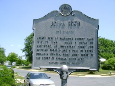
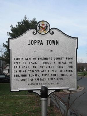
Joppa Town
← 2 miles
Inscription.
County seat of Baltimore County from 1712 to 1768. Once a rival of Baltimore, an important point for shipping tobacco and a Port of Entry. Benjamin Rumsey, first Chief Judge of the Court of Appeals, lived here.
Erected by Maryland Historical Society.
Topics. This historical marker is listed in these topic lists: Colonial Era • Landmarks • Political Subdivisions. A significant historical year for this entry is 1712.
Location. 39° 24.385′ N, 76° 21.797′ W. Marker is in Joppatowne, Maryland, in Harford County. Marker is at the intersection of Bridge Drive and Anchor Drive, on the right when traveling south on Bridge Drive. Touch for map. Marker is in this post office area: Joppa MD 21085, United States of America. Touch for directions.
Other nearby markers. At least 8 other markers are within 4 miles of this marker, measured as the crow flies. Rumsey Mansion (about 600 feet away, measured in a direct line); Gilmor's Raid (approx. 1.1 miles away); “Long Calm” (approx. 2.4 miles away); Union of Brother and Sisters of Ford’s Asbury Lodge No. 1 (approx. 2½ miles away); Gunpowder River (approx. 3.1 miles away); Franklinville (approx. 3.1 miles away); “Whitemarsh” (approx. 3.9 miles away); White Marsh War Memorial (approx. 3.9 miles away). Touch for a list and map of all markers in Joppatowne.
More about this marker. It appears that this marker was originally erected elsewhere, most likely on Route 40, about 2 miles from where Joppa Town was originally located.
Additional commentary.
1. Joppa Town
There are no existing buildings in the original Joppa Town. The village was on a navigable waterway that quickly silted in as adjoining land was cleared. The shore line has so drastically changed from 300 years ago, that nothing is known about the area.
— Submitted June 24, 2007, by Bill Pfingsten of Bel Air, Maryland.
Credits. This page was last revised on July 1, 2020. It was originally submitted on June 22, 2007, by Bill Pfingsten of Bel Air, Maryland. This page has been viewed 3,043 times since then and 46 times this year. Last updated on July 1, 2020, by Carl Gordon Moore Jr. of North East, Maryland. Photos: 1. submitted on June 22, 2007, by Bill Pfingsten of Bel Air, Maryland. 2. submitted on December 10, 2009, by James Rice of Kingsville, Maryland.

