Hartlepool, England, United Kingdom — Northwestern Europe (the British Isles)
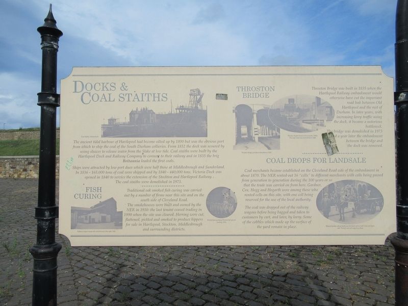
Docks & Coal Staiths
The ancient tidal harbour of Hartlepool had become silted up by 1800 but was the obvious port from which to ship the coal of the South Durham collieries. From 1832 the dock was scoured by using sluices to release water from the Slake at low tide. Coal staiths were built by the Hartlepool Dock and Railway Company to connect to their railway and in 1835 the brig Britannia loaded the first coals.
Ships were attracted by low port dues which were half those at Middlesbrough and Sunderland. In 1836 - 165,000 tons of coal were shipped and by 1840 - 440,000 tons. Victoria Dock was opened in 1840 to service the extension of the Stockton and Hartlepool Railway. The coal staiths were demolished in 1973.
Fish Curing
Traditional oak smoked fish curing was carried out by a number of firms near this site and on the south side of Cleveland Road. The smokehouses were built and owned by the NER in 1910: the last tenant ceased trading in 1990 when the site was cleared. Herring were cut, flattened, pickled and smoked to produce kippers for sale in Hartlepool, Stockton, Middlesbrough and surrounding districts.
Throston Bridge
Throston Bridge was built in 1835 when the Hartlepool Railway embankment would otherwise have cut the important road link between Old Hartlepool and the rest of Durham. In later years, with increasing lorry traffic using the dock, it became a notorious bottleneck. The bridge was demolished in 1973 and a year later the embankment between the bridge and the dock was removed.
Coal Drops for Landsale
Coal merchants became established on the Cleveland Road side of the embankment in about 1870. The NER rented out 16 "cells" to different merchants with cells being passed from generation to generation during the 100 years or so that the trade was carried on from here. Gardner, Cox, Hogg and Hogarth were among those who rented cells on this site, with one cell being reserved for the use of the local authority.
The coal was dropped out of the railway wagons before being bagged and taken to customers by cart, and later, by lorry. Some of the cobbles which made up the surface of the yard remain in place.
( photo captions )
Coal Staiths, Victoria Dock
Patison's kipper house with smokehouse to the right, 1982
Pickled herrings being “Pricked Out” prior to smoking, 1982.
Throston Ergine House and surrounds, 1980
The water tower was demolished in 1984
Throston Bridge just before demolition in 1973
Edward Gardner, whosa family was the first to rent a "cell” in the coal depot with “Tommy” and cart roady lor a show.
Topics. This historical marker is listed in this topic list: Industry & Commerce.
Location. 54° 42.109′ N, 1° 11.829′ W. Marker is in Hartlepool, England. Marker is at the intersection of W View Road and Thorpe Street, on the right when traveling west on W View Road. Touch for map. Marker is in this post office area: Hartlepool, England TS24 0EQ, United Kingdom. Touch for directions.
Other nearby markers. At least 8 other markers are within walking distance of this marker. Throston Engine House (here, next to this marker); Headland (a few steps from this marker); Seaton Tower Lighthouse (approx. 1.2 kilometers away); Naval Gun 4 inch (approx. 1.4 kilometers away); Ropes (approx. 1.4 kilometers away); 6 inch Gun (approx. 1.4 kilometers away); Naval & Anti Aircraft Gun (approx. 1.4 kilometers away); Malta Gun (approx. 1.4 kilometers away). Touch for a list and map of all markers in Hartlepool.
Credits. This page was last revised on January 27, 2022. It was originally submitted on November 5, 2018, by Michael Herrick of Southbury, Connecticut. This page has been viewed 270 times since then and 42 times this year. Photos: 1, 2. submitted on November 5, 2018, by Michael Herrick of Southbury, Connecticut.

