Woodbridge in Middlesex County, New Jersey — The American Northeast (Mid-Atlantic)
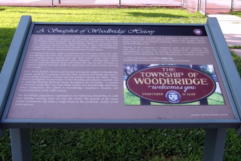
A Snapshot of Woodbridge History
In 1664, Governor of New Jersey Philip Carteret granted English settlers the right to establish a plantation of 14 square miles between the Passaic and Raritan Rivers purchased from the native Lenni Lenape tribe. Two years later, settlers from Newbury, Massachusetts, signed an agreement with Gov. Carteret to establish a Township. On June 1, 1669, King Charles II of England granted an official Town Charter to the settlers of Woodbridge, making it the oldest original township chartered in New Jersey.
It is believed the early settlers named the town after their pastor, Rev. John Woodbridge (1631-95); they laid the town out in a fashion similar to other New England towns, starting with the “Kirk Green: town center where churches, homes and businesses were clustered. Woodbridge’s prime location along the Raritan River and Arthur Kill and its later inclusion in regional railroad networks made it a destination for many families arriving from Europe.
Irish, Scots, English, French and German immigrants settled in Woodbridge proper, working in the potteries and fire brick factories that made the town a major global producer of brick and clay products during the 1800s. Many Italian immigrants found homes in Port Reading and played a pivotal role in building Reading Railroad tracks throughout the township. A Danish community made their way from Perth Amboy into Woodbridge and Fords. Many Hungarians also settled in Woodbridge, Hopelawn, Keasby and Fords at the turn of the 20th century.
The Township’s population continued to rise following World War II, with new families arriving from all over the world. The growth of the Asian Indian community has been a huge boost to the economic vitality of the Iselin section.
Today, Woodbridge Township has a population of nearly 100,000 and includes 10 smaller “towns” within its 24.2 square miles: Avenel, Colonia, Fords, Hopelawn, Iselin, Keasby, Menlo Park Terrace, Port Reading, Sewaren and Woodbridge proper.
Situated at the confluence of numerous water, rail and roadway links with 20% of its land area devoted to transportation, warehouse and manufacturing operations, Woodbridge Township is a major commercial hub in a central geographic location along the busy Northeast Corridor.
More information visit www.wthpc.org
Woodbridge Township Historic Preservation Commission
Mayor John E. McCormac Woodbridge Township 2013
Erected 2013 by Woodbridge Township Historic Preservation Commission.
Topics. This historical marker is listed in these topic lists: Colonial Era • Industry & Commerce • Settlements & Settlers. A significant historical date for this entry is June 1, 1669.
Location. 40° 33.398′ N, 74° 16.759′ W. Marker is in Woodbridge, New Jersey, in Middlesex County. Marker is on E Park Ave, on the left when traveling west. Touch for map. Marker is in this post office area: Woodbridge NJ 07095, United States of America. Touch for directions.
Other nearby markers. At least 8 other markers are within walking distance of this marker. Woodbridge History Trail (a few steps from this marker); General Nathaniel Heard (about 400 feet away, measured in a direct line); 44 Green Street (about 500 feet away); Fulton Street Train Wreck (about 500 feet away); First Presbyterian Church of Woodbridge (about 500 feet away); School Number 1 (about 500 feet away); Boynton Beach & Sewaren House Hotel (about 600 feet away); 87 Green Street (about 600 feet away). Touch for a list and map of all markers in Woodbridge.
Credits. This page was last revised on November 15, 2018. It was originally submitted on November 13, 2018, by Larry Gertner of New York, New York. This page has been viewed 436 times since then and 38 times this year. Photos: 1, 2. submitted on November 13, 2018, by Larry Gertner of New York, New York. • Andrew Ruppenstein was the editor who published this page.
Editor’s want-list for this marker. A wide view photo of the marker and the surrounding area together in context. • Can you help?

