South Queensferry in Edinburgh, Scotland, United Kingdom — Northwestern Europe (the British Isles)
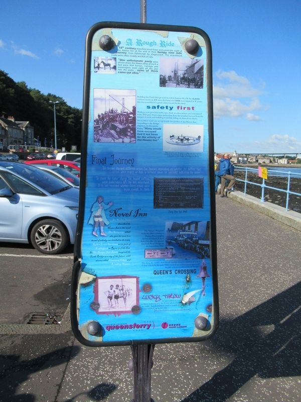
A Rough Ride
"One unfortunate party were driven down the Hawes Brae at such a fast pace that horses, carriage and passengers went right off the pier into the water – none of them came out alive.”
Building the Forth Bridge took its toll in human life. Of the 4,600 workers involved, 57 men died and over 500 were injured in 7 years – this was considered a good safety record for the time.
An accident ward was set up beside the garden of the Hawes Inn. According to the Bridge engineer, Sir Benjamin Baker, "Many would have escaped had it not been for the whisky of the Hawes Inn."
Final Journey
The ferries charged different prices for hearses depending on whether the coffins they carried were empty or full, a screwed down lid normally indicating the latter.
To avoid the higher charge for loaded coffins, some undertakers left the lids unscrewed. It is not recorded whether ferry crews were brave enough to check.
Novel Inn
Sir Walter Scott described the Hawes Inn in his novel The Antiquary, which also gave its name to a brand of whisky once bottled in the town.
Robert Louis Stephenson wrote part of Kidnapped in Room 13 of the Inn.
In The Bridge, Iain Banks imagined the Forth Bridge as a city of the future, with streets called Concourse Edgar and Keithing Avenue.
Queen’s Crossing
The ‘Queen Margaret’ made her final crossing to Hawes Pier, bring Queen Elizabeth II back from Fife after she opened the Forth Road Bridge on 4th September, 1964.
Lucky Throw
It was said to be lucky to throw a penny into the Forth when crossing by train. Local children used to search the shore for coins washed up by the tide.
( photo captions )
- This wooden raft, 21 metres in diameter, was used to measure the contours of the rock surrounding the two south piers of the bridge on Inchgarvie island.
- Ferry Price List, 1964
- The ferry, the world’s first electric paddle steamer, was one of a fleet of four which, in the early 1960s, carried two million passengers and 900,000 vehicles a year across the Forth.
Topics. This historical marker is listed in these topic lists: Bridges & Viaducts • Waterways & Vessels. A significant historical date for this entry is September 4, 1964.
Location. 55° 59.422′ N, 3° 23.18′ W. Marker is in South Queensferry, Scotland, in Edinburgh. Marker is at the intersection of Newhalls Road and Longcraig Road, on the left when traveling east on Newhalls Road. Touch for map. Marker is in this post office area: South Queensferry, Scotland EH30 9TA, United Kingdom. Touch for directions.
Other nearby markers. At least 8 other markers are within 6 kilometers of this marker, measured as the crow flies. Briggers Memorial (here, next to this marker); The Royal Navy in the Forth (about 90 meters away, measured in a direct line); The Forth Rail Bridge (about 150 meters away); Forth Bridge (approx. 0.6 kilometers away); John Reid (approx. 0.6 kilometers away); In Gratitude (approx. 0.6 kilometers away); Queensbury War Memorial (approx. 0.7 kilometers away); 603 (City of Edinburgh) Squadron (approx. 5.3 kilometers away). Touch for a list and map of all markers in South Queensferry.
Also see . . . Forth Bridge on Wikipedia. (Submitted on December 4, 2018, by Michael Herrick of Southbury, Connecticut.)
Credits. This page was last revised on January 27, 2022. It was originally submitted on December 4, 2018, by Michael Herrick of Southbury, Connecticut. This page has been viewed 136 times since then and 12 times this year. Last updated on December 26, 2018, by T. Patton of Jefferson, Georgia. Photos: 1, 2, 3. submitted on December 4, 2018, by Michael Herrick of Southbury, Connecticut.


