Maggie Valley in Haywood County, North Carolina — The American South (South Atlantic)
Kirk's Raid
Unwanted Intruders
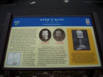
Kirk reached Waynesville on February 4 and sacked the town, ordering his men to burn the home of Revolutionary War hero Colonel Robert Love. The raiders also opened the Waynesville jail, liberated its prisoners (mostly local Unionists confined by Confederate authorities), and destroyed the building.
After wreaking havoc on the village of Waynesville, Kirk marched his troops toward Tennessee and camped at Balsam Gap, where a small contingent of Home Guards and farmers attacked the raiders. Kirk retreated first to Waynesville and then to Soco Gap. As Kirk approached Soco Gap, Lt. Robert T. Conley's sharpshooters of Thomas's Legion attacked. Kirk ordered a swift retreat to Balsam Gap, where the Federals escaped into Tennessee less than a week after the raid began.
Sidebar: In 1863, local resident Solomon Finger enlisted in Co. E, 29th North Carolina Infantry, at age 44, leaving his wife and five young children at home. He was captured on July 22, 1864, during the Battle of Atlanta and imprisoned in Camp Chase, Ohio. When a flu epidemic later struck Maggie Valley, he was informed by telegram that all five of his children had died. Released at the end of the war, Finger survived a walk of more than 100 miles and a murder attempt during his long journey home. He and his wife, Eliza, later had four more children. Finger and his entire family are buried nearby.
Erected by North Carolina Civil War Trails.
Topics and series. This historical marker is listed in this topic list: War, US Civil. In addition, it is included in the North Carolina Civil War Trails series list. A significant historical month for this entry is February 1855.
Location. 35° 31.266′ N, 83° 6.403′ W. Marker is in Maggie Valley, North Carolina, in Haywood County. Marker is on Soco Road (State Highway 19). Touch for map. Marker is in this post office area: Maggie Valley NC 28751, United States of America. Touch for directions.
Other nearby markers. At least 8 other markers are within 6 miles of this marker, measured as the crow flies. Felix Walker (approx. 2.3 miles away); Qualla Boundary (approx. 3.3 miles away); The Masonic Marker (approx. 3.8 miles away); Plott Balsam (approx. 3.9 miles away); An Ancient and Settled Landscape (approx. 4.7 miles away); Qualla Indian Reservation (approx. 4.7 miles away); Browning Knob (approx. 4.8 miles away); Rutherford Trace (approx. 5.9 miles away). Touch for a list and map of all markers in Maggie Valley.
More about this marker. In the upper center are portraits of Col. George W. Krick and Lt. Robert T. Conley. A portrait of Solomon Finger is inside the sidebar. A map of the Maggie Valley area is on the lower left.
Credits. This page was last revised on June 16, 2016. It was originally submitted on October 23, 2008, by Stanley and Terrie Howard of Greer, South Carolina. This page has been viewed 2,423 times since then and 76 times this year. Photos: 1, 2. submitted on October 23, 2008, by Stanley and Terrie Howard of Greer, South Carolina. • Craig Swain was the editor who published this page.

