Old Glebe in Arlington in Arlington County, Virginia — The American South (Mid-Atlantic)
Welcome to Fort Ethan Allen
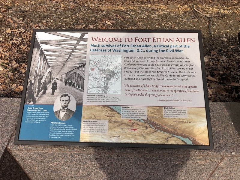
Much survives of Fort Ethan Allen, a critical part of the Defenses of Washington, D.C., during the Civil War.
Fort Ethan Allen defended the southern approaches to Chain Bridge, one of the three Potomac River crossings that Confederate troops could have used to invade Washington. Unlike many Civil War sites, Fort Ethan Allen saw no major battles—but that does not diminish its value. The fort's very existence deterred an assault. The Confederate Army never launched an attack that captured the nation's capital.
"The possession of Chain Bridge communication with the opposite shore of the Potomac … was essential to the operation of our forces in Virginia and to the prestige of our arms."(captions)
—General John G. Barnard, U.S. Army, 1871
Chain Bridge from Washington, D.C., 1865
Military control of the bridge began in 1861 so that Union soldiers could maintain communications and troop movements across the Potomac between Washington and Union-held territory in Virginia.
Abraham Lincoln
In late May 1861, President Lincoln approved his generals' plans to build fortifications in strategic areas of northern Virginia across the Potomac River from the nation's capital. Lincoln inspected Fort Ethan Allen during its construction in September 1861.
Defenses of Washington
Washington, D.C., was the most heavily fortified city in the Union during the Civil War. By the war's end, 164 forts and batteries formed a 37-mile defensive perimeter.
Fort Ethan Allen
The fort was strategically located on high ground between Pimmit Run and Gulf Branch, a natural ravine. Surrounding land was cleared of trees to open sight lines in all directions.
Fort Marcy
Fort Marcy also protected Chain Bridge, while it and Fort Ethan Allen protected each other. Ditches and rifle pits connected the two forts and their fields overlapped.
Chain Bridge
The strategic importance of Chain Bridge was reflected in the degree of protection it received on both sides of the Potomac.
Topics and series. This historical marker is listed in these topic lists: Bridges & Viaducts • Forts and Castles • War, US Civil. In addition, it is included in the Defenses of Washington, and the Former U.S. Presidents: #16 Abraham Lincoln series lists. A significant historical month for this entry is May 1861.
Location. 38° 55.419′ N, 77° 7.463′ W. Marker is in Arlington, Virginia, in Arlington County. It is in Old Glebe. Marker can be reached from North Stafford Street north of North Old Glebe Road
Other nearby markers. At least 8 other markers are within walking distance of this marker. A Defensive Stronghold, Heavily Armed (here, next to this marker); A Bastion-Style Fort Is a Mighty Fortress (here, next to this marker); Fort Ethan Allen (within shouting distance of this marker); A Defensive Artillery Fort (within shouting distance of this marker); The View in 1865 (within shouting distance of this marker); Saegmuller Public School (about 400 feet away, measured in a direct line); Protecting the Fort (about 400 feet away); Lives of the Soldiers (about 400 feet away). Touch for a list and map of all markers in Arlington.
Credits. This page was last revised on September 14, 2023. It was originally submitted on January 27, 2019, by Devry Becker Jones of Washington, District of Columbia. This page has been viewed 407 times since then and 33 times this year. Photos: 1, 2. submitted on January 27, 2019, by Devry Becker Jones of Washington, District of Columbia. 3, 4. submitted on September 13, 2023, by steele Harrison knudson of Arlington, Virginia. • Bernard Fisher was the editor who published this page.


