Alton in Madison County, Illinois — The American Midwest (Great Lakes)
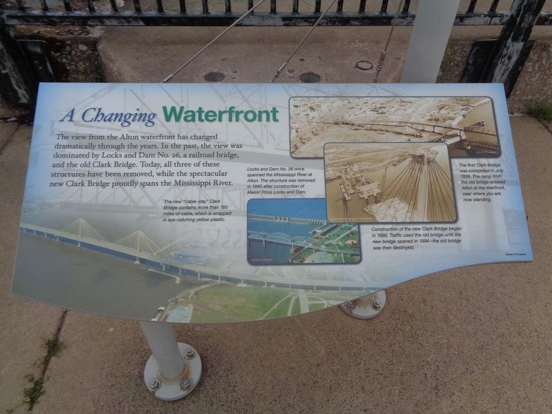
A Changing Waterfront
Inscription.
The view from the Alton waterfront has changed dramatically through the years. In the past, the view was dominated by Locks and Dam No. 26, a railroad bridge, and the old Clark Bridge. Today, all three of these structures have been removed, while the spectacular new Clark Bridge proudly spans the Mississippi River.
[Captions]
The new "cable-stay" Clark Bridge contains more than 160 miles of cable, which is wrapped in the eye-catching yellow plastic.
Lock and Dam No. 26 once spanned the Mississippi River at Alton. The structure was removed in 1990 after construction of Melvin Price Locks and Dam.
Construction of the new Clark Bridge began in 1990. Traffic used the old bridge until the new bridge opened in 1994—the old bridge was then destroyed.
The first Clark Bridge was completed in 1928. The ramp from the old bridge entered Alton at the riverfront, near where you are now standing.
Erected by US Army Corps of Engineers St. Louis District; City of Alton, Illinois.
Topics. This historical marker is listed in these topic lists: Bridges & Viaducts • Railroads & Streetcars • Waterways & Vessels. A significant historical year for this entry is 1990.
Location. 38° 53.17′ N, 90° 10.921′ W. Marker is in Alton, Illinois, in Madison County. Marker is on Riverfront Drive west of Boat Launch Road, on the right when traveling east. Touch for map. Marker is at or near this postal address: 1 Riverfront Drive, Alton IL 62002, United States of America. Touch for directions.
Other nearby markers. At least 8 other markers are within walking distance of this marker. Great River Floods (within shouting distance of this marker); Smallpox Island (within shouting distance of this marker); The Duel That Never Happened (within shouting distance of this marker); Alton and the Flood of '93 (about 400 feet away, measured in a direct line); Ryder Building (approx. 0.3 miles away); Discover History All Around Alton (approx. 0.3 miles away); Lincoln-Douglas Debates! (approx. 0.3 miles away); Lincoln-Douglas Debate, Alton (approx. 0.3 miles away). Touch for a list and map of all markers in Alton.
Credits. This page was last revised on May 10, 2021. It was originally submitted on May 2, 2019, by Devry Becker Jones of Washington, District of Columbia. This page has been viewed 208 times since then and 14 times this year. Photos: 1, 2. submitted on May 9, 2021, by Jason Voigt of Glen Carbon, Illinois.

