St. Simons Island in Glynn County, Georgia — The American South (South Atlantic)
Early History of St. Simons Island
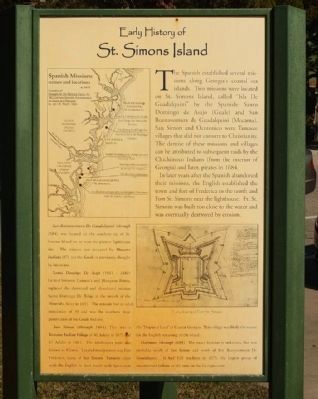
The Spanish established several missions along Georgia's coastal sea islands. Two missions were located on St. Simons Island, called " Isla De Guadalquini" by the Spanish: Santo Domingo de Asajo (Guale) and San Buenaventura de Guadalquini (Mocama). San Simon and Ocotonico were Yamasee villages that did not convert to Christianity. The demise of these missions and villages can be attributed to subsequent raids by the Chichimeco Indians ( from the interior of Georgia ) and later, pirates in 1684.
In later years after the Spanish abandoned their missions, the English established the town and fort of Frederica to the north and Fort St. Simons near the lighthouse. Ft. St. Simons was built too close to the water and was eventually destroyed by erosion.
San Buenaventura de Guadalquini (through 1684) was located on the southern tip of St. Simons Island on or near the present lighthouse site. The mission was occupied by Mocama Indians (87), not the Gaule as previously thought by historians.
Santa Domingo de Asajo (1661 - 1684) located between Cannon's and Hampton Points, replaced the destroyed and abandoned mission Santo Domingo de Talaje at the mouth of the Altamaha River in 1681. The mission had an adult population of 39 and was the southern most penetration of the Guale Indians.
San Simon (through 1684) This was a Yamassee Indian Village of 40 adults in 1675 and 17 adults in 1681. The inhabitants were also known as Clones. Located near present-day Fort Frederica, many of San Simons Yamasee sided with the English in their battle with Spain over the "Disputed Land" of Coastal Georgia. This village was likely the source for the English renaming of the island.
Ocotonio (through 1684) The exact location is unknown, but was probably south of San Simon and north of San Buenaventura de Guadalquini. It had 120 residents in 1675, the largest group of unconverted Indians at the time on the Georgia Coast.
Erected by Coastal Georgia Historical Society.
Topics. This historical marker is listed in these topic lists: Colonial Era • Native Americans • Notable Events • Settlements & Settlers. A significant historical year for this entry is 1684.
Location. 31° 8.036′ N, 81° 23.618′ W. Marker is on St. Simons Island, Georgia, in Glynn County. Marker is on 12th Street, on the right when traveling south. Touch for map. Marker is at or near this postal address: 101 12th Street, Saint Simons Island GA 31522, United States of America. Touch for directions.
Other nearby markers. At least 8 other markers are within walking distance of this marker. The First Lighthouse ~ 1810 (here, next to this marker);
The Historic St. Simons Light Station (here, next to this marker); Historic St. Simons Lighthouse (a few steps from this marker); Fort St. Simons (a few steps from this marker); Couper's Point (a few steps from this marker); a different marker also named Fort St. Simons (within shouting distance of this marker); Keepers of the Light (within shouting distance of this marker); a different marker also named Fort St. Simons (within shouting distance of this marker). Touch for a list and map of all markers in St. Simons Island.
Credits. This page was last revised on November 23, 2020. It was originally submitted on November 9, 2008, by Mike Stroud of Bluffton, South Carolina. This page has been viewed 2,462 times since then and 121 times this year. Photos: 1. submitted on May 3, 2012, by Mike Stroud of Bluffton, South Carolina. 2, 3. submitted on November 9, 2008, by Mike Stroud of Bluffton, South Carolina. • Kevin W. was the editor who published this page.

![<i>[Upper marker picture]</i> Spanish Missions names and locations a. 1675. Click for full size. <i>[Upper marker picture]</i> Spanish Missions names and locations a. 1675 image. Click for full size.](Photos/42/Photo42976.jpg?11252005)
![<i>[Lower marker picture]</i> Early Drawing of Fort St. Simons. Click for full size. <i>[Lower marker picture]</i> Early Drawing of Fort St. Simons image. Click for full size.](Photos/42/Photo42977.jpg?11252005)