Rouseville in Venango County, Pennsylvania — The American Northeast (Mid-Atlantic)
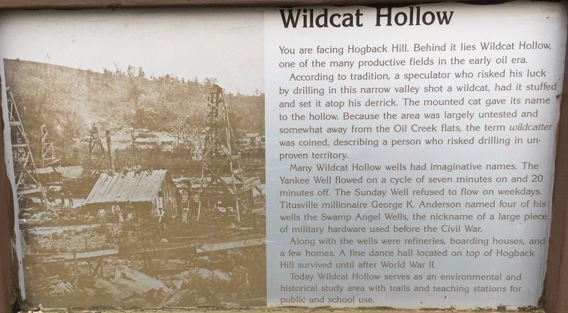
Wildcat Hollow
You are facing Hogback Hill. Behind it lies Wildcat Hollow, one of the many productive fields in the early oil era.
According to tradition, a speculator who risked his luck by drilling in this narrow valley shot a wildcat, had it stuffed and set it atop his derrick. The mounted cat gave its name to the hollow. Because the area was largely untested and somewhat away from the Oil Creek flats, the term wildcatter was coined, describing a person who risked drilling in unproven territory.
Many Wildcat Hollow wells had imaginative names. The Yankee Well flowed on a cycle of seven minutes on and 20 minutes off. The Sunday Well refused to flow on weekdays. Titusville millionaire George K. Anderson named four of his wells the Swamp Angel Wells, the nickname of a large piece of military hardware used before the Civil War.
Along with the wells were refineries, boarding houses, and a few homes. A fine dance hall located on top of Hogback Hill survived until after World War II.
Today Wildcat Hollow serves as an environmental and historical study area with trails and teaching stations for public and school use.
Topics. This historical marker is listed in this topic list: Industry & Commerce.
Location. 41° 31.074′ N, 79° 41.001′ W. Marker is in Rouseville, Pennsylvania, in Venango County. Marker is at the intersection of State Park Road (Pennsylvania Route 1007) and Petroleum Centre Road on State Park Road. At Visitors Center. Touch for map. Marker is in this post office area: Rouseville PA 16344, United States of America. Touch for directions.
Other nearby markers. At least 8 other markers are within 4 miles of this marker, measured as the crow flies. Welcome to Petroleum Centre (within shouting distance of this marker); Toll Bridge (about 700 feet away, measured in a direct line); Hyde & Egbert Farm, and the McCray Tract (about 800 feet away); Coy Coquette Locates Gusher (approx. ¼ mile away); McClintock-Steele-Waitz House (approx. 2½ miles away); Rynd Farm (approx. 2½ miles away); Humboldt Refinery (approx. 2.7 miles away); Pithole (approx. 3.3 miles away). Touch for a list and map of all markers in Rouseville.
Also see . . .
1. Wild-Catter. Wikipedia entry (Submitted on June 4, 2019, by Steve Stoessel of Niskayuna, New York.)
2. Oil Creek State Park. Pennsylvania Department of Conservation and Natural Resources website entry (Submitted on September 7, 2022, by Larry Gertner of New York, New York.)
3. Oil Creek State Park Map. (Submitted on June 4, 2019, by Steve Stoessel of Niskayuna, New York.)
Credits. This page was last revised on September 7, 2022. It was originally submitted on June 4, 2019, by Steve Stoessel of Niskayuna, New York. This page has been viewed 361 times since then and 31 times this year. Photo 1. submitted on June 4, 2019, by Steve Stoessel of Niskayuna, New York. • Andrew Ruppenstein was the editor who published this page.
