Roseau, Saint George, Dominica — Caribbean Region of the Americas (Lesser Antilles of the West Indies)
Morne Bruce Garrison
The Defence of Roseau
Morne Bruce Garrison
The Defence of Roseau
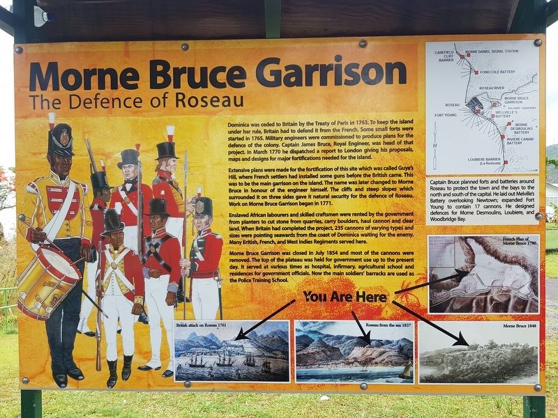
Dominica was ceded to Britain by the Treaty of Paris in 1763. To keep the island under her rule, Britain had to defend it from the French. Some small forts were started in 1765. Military engineers were commissioned to produce plans for the defence of the colony. Captain James Bruce, Royal Engineer, was head of that project. In March 1770 he dispatched a report to London giving his proposals, maps and designs for major fortifications needed for the island.
Extensive plans were made for the fortification of this site which was called Guye's Hill, where French settlers had installed some guns before the British came. This was to be the main garrison on the island. The name was later changed to Morne Bruce in honour of the engineer himself. The cliffs and steep slopes which surrounded it on three sides gave it natural security for the defence of Roseau. Work on Morne Bruce Garrison began in 1771.
Enslaved African labourers and skilled craftsmen were rented by the government from planters to cut stone from quarries, carry boulders, haul cannon and clear land. When Britain had completed the project, 235 cannons of varying types and sizes were pointing seawards from the coast of Dominica waiting for the enemy. Many British, French, and West Indies Regiments served here.
Morne Bruce Garrison was closed in July 1854 and most of the cannons were removed. The top of the plateau was held for government use up to the present day. It served at various times as hospital, infirmary, agricultural school and residences for government officials. Now the main soldiers' barracks are used as the Police Training School.
Sidebar:
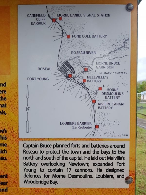
Captain Bruce planned forts and batteries around Roseau to protect the town and the bays to the north and south of the capital. He laid out Melville’s Battery overlooking Newtown; expanded Fort Young to contain 17 cannons. He designed defences for Morne Desmoulins, Loubiere, and Woodbridge Bay.
Captions:
French Plan of Morne Bruce 1780
British attack on Roseau 1761
Roseau from the sea 1837
Morne Bruce 1848
Topics. This historical marker is listed in these topic lists: Colonial Era • Forts and Castles • Man-Made Features • Wars, Non-US. A significant historical month for this entry is March 1770.
Location. 15° 17.935′ N, 61° 22.753′ W. Marker is in Roseau, Saint George. Marker is on Morne Bruce Road, on the left when traveling north. Touch for map. Touch for directions.
Other nearby markers. At least 8 other markers are within walking distance of this marker. A different marker also named Morne Bruce Garrison (about 150 meters away, measured in a direct line); David the Goliath (approx. 0.4 kilometers away); Roseau Cathedral (approx.
0.7 kilometers away); Methodist Church (approx. 0.8 kilometers away); Carnegie Library of Roseau (approx. 0.8 kilometers away); Anglican Church (approx. 0.8 kilometers away); World Wars Memorial (approx. 0.8 kilometers away); Glory to the French from Dominica (approx. 0.9 kilometers away). Touch for a list and map of all markers in Roseau.
Credits. This page was last revised on June 16, 2019. It was originally submitted on June 16, 2019, by J. Makali Bruton of Accra, Ghana. This page has been viewed 648 times since then and 83 times this year. Photos: 1, 2, 3, 4. submitted on June 16, 2019, by J. Makali Bruton of Accra, Ghana.


