Downtown in Norfolk, Virginia — The American South (Mid-Atlantic)
The Cannonball Trail
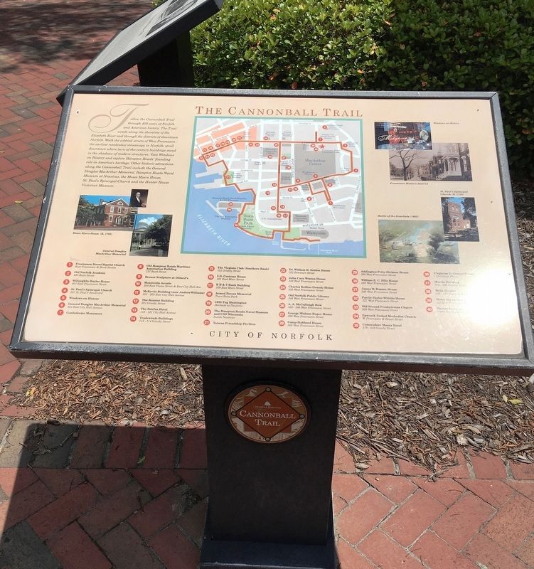
Follow the Cannonball Trail through 400 years of Norfolk and American history. The Trail winds along the shoreline of the Elizabeth River and through the districts of downtown Norfolk. Walk the cobbled streets of West Freemason - the earliest residential streetscape in Norfolk; stroll downtown where the turn-of-the-century buildings stand in the shadows of modern structures. Visit Windows on History and explore Hampton Road's founding role in American's heritage. Other historic attractions along the Cannonball Trail include General Douglas MacArthur Memorial, Hampton Roads Naval Museum, at Nautilus, the Moses Myers House, St. Paul's Episcopal Church and the Hunter House Victorian Museum.
1. Freemason Street Baptist Church East Freemason & Bank Streets
2. Old Norfolk Academy 420 Bank Street
3. Willoughby-Baylor House 601 East Freemason Street
4, St. Paul's Episcopal Church 3=210 St. Paul's Boulevard
5. Windows on History
6. General Douglas MacArthur Memorial
7. Confederate Monument
8. Old Hampton Roads Maritime Association Building 127 Bank Street
9. Bronze Sculpture at Dillard's
10. Monticello Arcade 208 East Plume Street & East City Ave 11. McKevitt Building (now Anders-Williams) 201 -203 East City Hall Ave
12, The Royster Building 201 Granby Street
13. The Fairfax Hotel 113-121- City Hall Ave
14. Tradewinds Buildings 112-114 Granby Street
15. The Virginia Club (South Bank) 101 Granby Street
16. U. S. Customs House 101 East Main Street
17. B B & T Bank Building 109 East Main Street
18. Armed Forces Memorial Town Point Park
19. 133 Tung Hunting Dockside at Nauticus
20. The Hampton Roads Naval Museum and USS Wisconsin Inside Nauticus
21. Taiwan Friendship Pavilion
22. Dr. William B, Selden House 351 Botetourt Street
23. John Cary Weston House 358 West Freemason Street
24. Charles Rollins Granby House 355 West Freemason Street
25. Old Norfolk Public Library 345 West Freemason Street
26. A. A. McCullough Row 228-346 West Freemason Street
27. George Wisham Roper House 320 West Freemason Street
28. Camp-Hubbard House 308 West Freemason Street
29.Addington-Petty-Dickson House 300 West Freemason Street
30. William E. C. Ellis House 256 West Freemason Street
31. James W. Hunter House 240 West Freemason Street
32. Purdie-Taylor-Whittle House 227 West Freemason Street
33. Old Second Presbyterian Church 209 West Freemason Street
34. Epworth United Methodist Church
2. Freemason & Boush Street
35. Commodore Maury Hotel 339-349 Granby Street
36. Virginius D. Groner House 112 College Place
37. Martin Building 300-306 Granby Street
38. Wells Theater 108-116 Tazewell Street
39. Moses Myers House 323 East Freemason Street
40. Bronze Sculpture North Entrance to Mall
Erected by City of Norfolk.
Topics. This historical marker is listed in these topic lists: Architecture • Churches & Religion • Colonial Era.
Location. 36° 51.013′ N, 76° 17.23′ W. Marker is in Norfolk, Virginia. It is in Downtown. Marker is on E Freemason Street, 0.1 miles east of Bank Street, on the right when traveling east. Touch for map. Marker is at or near this postal address: 401 E Freemason St, Norfolk VA 23510, United States of America. Touch for directions.
Other nearby markers. At least 8 other markers are within walking distance of this marker. Whitehead House, 1791 (a few steps from this marker); Moses Myers House, 1792 (a few steps from this marker); Freemason Street Baptist Church (within shouting distance of this marker); St. Joseph’s Catholic Church & School (about 500 feet away, measured in a direct line); Willoughby-Baylor House, 1794 (about 500 feet away); Bank Street Baptist Church (about 600 feet away); Francis Drake, Free Black Barber (about 700 feet away); Epworth United Methodist Church, 1894 (about 700 feet away). Touch for a list and map of all markers in Norfolk.
Credits. This page was last revised on February 1, 2023. It was originally submitted on July 8, 2019, by Brandon D Cross of Flagler Beach, Florida. This page has been viewed 238 times since then and 26 times this year. Photos: 1, 2. submitted on July 8, 2019, by Brandon D Cross of Flagler Beach, Florida. • Bill Pfingsten was the editor who published this page.

