Vischer Ferry in Saratoga County, New York — The American Northeast (Mid-Atlantic)
Vischer Ferry Nature and Historic Preserve
Inscription.
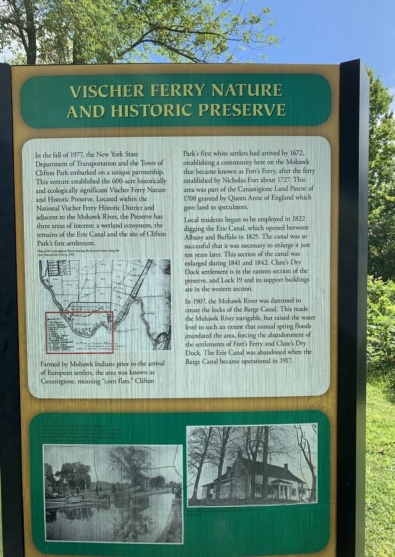
In the fall of 1977, the New York State
Department of Transportation and the Town of
Clifton Park embarked on a unique partnership.
This venture established the 600-acre historically
and ecologically significant Vischer Ferry Nature
and Historic Preserve. Located within the National Vischer Ferry Historic District and
adjacent to the Mohawk River, the Preserve has
three areas of interest: a wetland ecosystem, the
remains of the Erie Canal and the site of Clifton
Park's first settlement.
Farmed by Mohawk Indians prior of European settlers, the area was known as Canastigione, meaning "corn flats.” Clifton Park's first white settlers had arrived by 1672, establishing a community here on the Mohawk that became known as Fort's Ferry, after the ferry established by Nicholas Fort about 1727. This area was part of the Canastigione Land Patent of 1708 granted by Queen Anne of England which gave land to speculators.
Local residents began to be employed in 1822 digging the Erie Canal, which opened between Albany and Buffalo in 1825. The canal was so successful that it was necessary to enlarge it just ten years later. This section of the canal was enlarged during 1841 and 1842. Clute's Dry Dock settlement is in the eastern section of the preserve, and Lock 19 and its support buildings are in the western section.
In 1907, the Mohawk River was dammed to create the locks of the Barge Canal. This made the Mohawk River navigable, but raised the water level to such an extent that annual spring floods inundated the area, forcing the abandonment of the settlements of Fort's Ferry and Clute's Dry Dock. The Erie Canal was abandoned when the Barge Canal became operational in 1917.
Erected by America’s Byways.
Topics and series. This historical marker is listed in these topic lists: Parks & Recreational Areas • Settlements & Settlers • Waterways & Vessels. In addition, it is included in the Erie Canal series list. A significant historical year for this entry is 1977.
Location. 42° 47.576′ N, 73° 47.742′ W. Marker is in Vischer Ferry, New York, in Saratoga County. Marker is at the intersection of Riverview Road and Van Vranken Road, on the right when traveling east on Riverview Road. Touch for map. Marker is in this post office area: Rexford NY 12148, United States of America. Touch for directions.
Other nearby markers. At least 8 other markers are within walking distance of this marker. Cast Iron Whipple Truss Bridge, 1869 (here, next to this marker); Whipple Iron Truss Bridge (within shouting distance of this marker); Erie Canal (within shouting distance of this marker); Fort's Ferry (approx. 0.4 miles away); Van Vranken Home, 1847 (approx. 0.7 miles away); Van Vranken Farm (approx. 0.9 miles away); Clutes Dry Dock (approx. one mile away); a different marker also named Clute’s Dry Dock (approx. one mile away). Touch for a list and map of all markers in Vischer Ferry.
Credits. This page was last revised on September 9, 2019. It was originally submitted on September 5, 2019, by Steve Stoessel of Niskayuna, New York. This page has been viewed 261 times since then and 20 times this year. Photos: 1, 2, 3, 4. submitted on September 5, 2019, by Steve Stoessel of Niskayuna, New York. • Andrew Ruppenstein was the editor who published this page.


