Near Whitehead in Guysborough County, Nova Scotia — The Atlantic Provinces (North America)
Whitehead
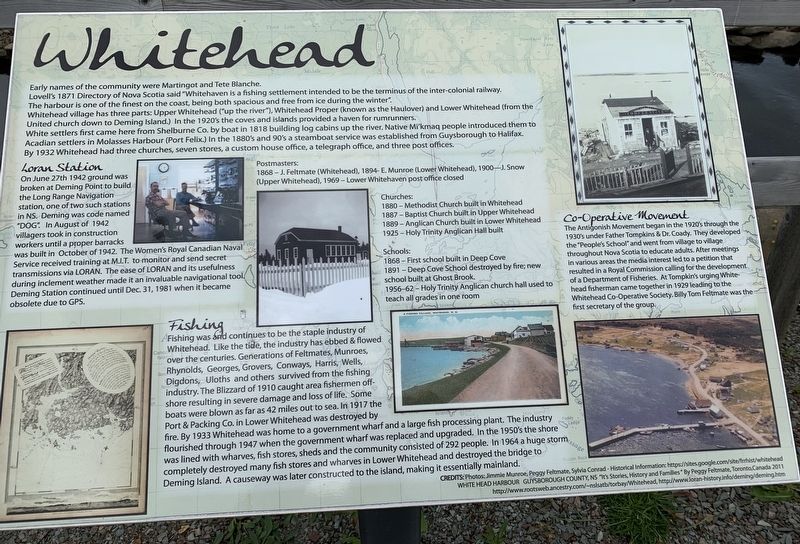
Early names of the community were Martingot and Tete Blanche.
Lovell's 1871 Directory of Nova Scotia said "Whitehaven is a fishing settlement intended to be the terminus of the inter-colonial railway. The harbour is one of the finest on the coast, being both spacious and free from ice during the winter."
Whitehead village has three parts: Upper Whitehead ("up the river"), Whitehead Proper (known as the Haulover) and Lower Whitehead (from the United church down to Deming Island.) In the 1920's the coves and islands provided a haven for rumrunners. White settlers first came here from Shelburne Co. by boat in 1818 building log cabins up the river. Native Mi'kmaq people introduced them to Acadian settlers in Molasses Harbour (Port Felix.) In the 1880's and 90's a steamboat service was established from Guysborough to Halifax. By 1932 Whitehead had three churches, seven stores, a custom house office, a telegraph office, and three post offices.
Loran Station
On June 27th 1942 ground broken at Deming Point to build the Long Range Navigation station, one of two such stations in NS. Deming was code named "DOG". In August of 1942 villagers took in construction workers until a proper barracks was built in October of 1942. The Women's Royal Canadian Naval Service received training at M.I.T. to monitor and send secret transmissions via LORAN. The ease of LORAN and its usefulness during inclement weather made it an invaluable navigational tool. Deming Station continued until Dec. 31, 1981 when it became obsolete due to GPS.
Fishing
Fishing was and continues to be the staple industry of Whitehead. Like the tide, the industry has ebbed & flowed over the centuries. Generations of Feltmates, Munroes, Rhynolds, Georges, Grovers, Conways, Harris, Wells, Digdons, Uloths and others survived from the fishing industry. The Blizzard of 1910 caught area fishermen offshore resulting in severe damage and loss of life. Some boats were blown as far as 42 miles out to sea. In 1917 the Port & Packing Co. in Lower Whitehead was destroyed by fire. By 1933 Whitehead was home to a government wharf and a large fish processing plant. The industry flourished through 1947 when the government wharf was replaced and upgraded. In the 1950's the shore was lined with wharves, fish stores, sheds and the community consisted of 292 people. In 1964 a huge storm completely destroyed many fish stores and wharves in Lower Whitehead and destroyed the bridge to Deming Island. A causeway was later constructed to the island, making it essentially mainland.
Co-Operative Movement
The Antigonish Movement began in the 1920's through the 1930's under Father Tompkins & Dr. Coady. They developed the "People's School” and went from village to village throughout Nova Scotia to educate adults. After meetings in various areas the media interest led to a petition that resulted in a Royal Commission calling for the development of a Department of Fisheries. At Tompkin's urging Whitehead fisherman came together in 1929 leading to the Whitehead Co-Operative Society. Billy Tom Feltmate was the first secretary of the group.
Postmasters:
1868 - J. Feltmate (Whitehead)
1894 - E. Munroe (Lower Whitehead)
1900 - J. Snow (Upper Whitehead)
1969 - Lower Whitehaven post office closed
Churches:
1880 -Methodist Church built in Whitehead
1887 - Baptist Church built in Upper Whitehead
1889 - Anglican Church built in Lower Whitehead
1925 - Holy Trinity Anglican Hall built
Schools:
1868 - First school built in Deep Cove
1891 - Deep Cove School destroyed by fire; new school built at Ghost Brook.
1956-62 - Holy Trinity Anglican church hall used to teach all grades in one room.
Topics. This historical marker is listed in this topic list: Settlements & Settlers. A significant historical date for this entry is June 27, 1942.
Location. 45° 14.504′ N, 61° 11.425′ W. Marker is near Whitehead, Nova Scotia, in Guysborough County. Marker is on Whitehead Road, on the left when traveling south. Touch for map. Marker is in this post office area: Whitehead NS B0H 1T0, Canada. Touch for directions.
Other nearby markers. At least 8 other markers are within 8 kilometers of this marker, measured as the crow flies. The Canal (here, next to this marker); Yankee Cove (here, next to this marker); Port Felix (about 150 meters away, measured in a direct line); Folklore & Trivia (about 150 meters away); Captain Savalette (approx. 2.3 kilometers away); Welcome to Place Savalette (approx. 2.3 kilometers away); #5 Radar Unit R.C.A.F Station (approx. 7.1 kilometers away); We Will Remember/Nous Nous Souviendrons (approx. 7.1 kilometers away). Touch for a list and map of all markers in Whitehead.
Credits. This page was last revised on October 3, 2019. It was originally submitted on September 30, 2019, by Steve Stoessel of Niskayuna, New York. This page has been viewed 405 times since then and 53 times this year. Photo 1. submitted on September 30, 2019, by Steve Stoessel of Niskayuna, New York. • Andrew Ruppenstein was the editor who published this page.
Editor’s want-list for this marker. Photo of the marker within its surroundings. • Can you help?
