El Call in Barcelona, Catalonia, Spain — Southwestern Europe (Iberian Peninsula)
The Aerial Bombing of the Plaza / El Bombardeo de la Plaza / El Bombardeig de la Plaça
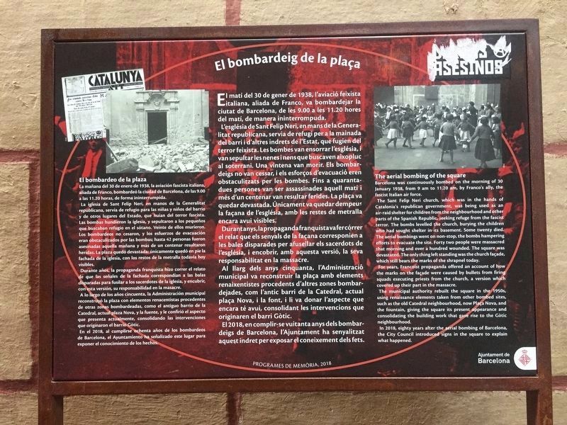
The Aerial Bombing of the Plaza
Barcelona was continuously bombed on the morning of 30 January 1938, from 9 am to 11.20 am, by Franco's ally, the fascist Italian air force.
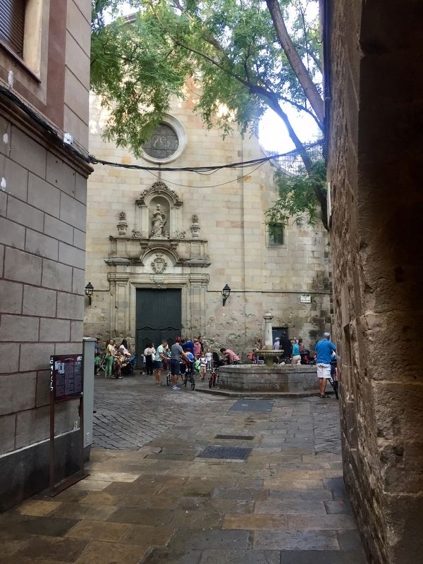
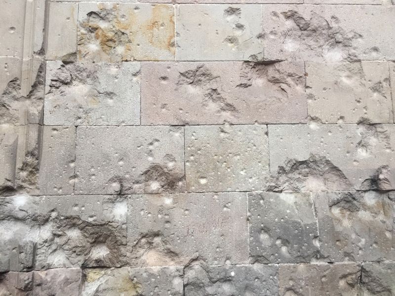
The Sant Felip Neri church, which was in the hands of Catalonia's republican government, was being used as an air-raid shelter for children from the neighbourhood and other parts of the Spanish Republic, seeking refuge from the fascist terror. The bombs levelled the church, burying the children who had sought shelter in its basement. Some twenty died. The aerial bombings went on non-stop, the bombs hampering efforts to evacuate the site. Forty two people were massacred that morning and over a hundred wounded. The square was devastated. The only thing left standing was the church façade, which still bears the marks of the shrapnel today.
For years, Francoist propaganda offered an account of how the marks on the façade were caused by bullets from firing squads executing priests from the church, a version which covered up their part in the massacre.
The municipal authority rebuilt the square in the 1950s, using renaissance elements taken from other bombed sites, such as the old Catedral neighbourhood, now Plaça Nova, and the fountain, giving the square its present appearance and consolidating the building work that gave rise to the Gòtic neighbourhood.
In 2018, eighty years after the aerial bombing of Barcelona, the City Council introduced signs in the square to explain what happened.
-
(Catalan:)
El matí del 30 de gener de 1938, l'aviació feixista italiana, aliada de Franco, va bombardejar la ciutat de Barcelona, de les 9.00 a les 11.20 hores del matí, de manera ininterrompuda.
L'església de Sant Felip Neri, en mans de la Generalitat republicana, servia de refugi per a la mainada del barri i d'altres indrets de l'Estat, que fugien del terror feixista. Les bombes van ensorrar l'església, i van sepultar les nenes i nens que buscaven aixopluc al soterrani. Una vintena van morir. Els bombardeigs no van cessar, i els esforços d'evacuació eren obstaculitzats les bombes. Fins a quarantaper dues persones van ser assassinades aquell matí i més d'un centenar van resultar ferides. La plaça va quedar devastada. Únicament va quedar dempeus la façana de l'església, amb les restes de metralla encara avui visibles.
Durantanys,la propaganda
franquista va fer córrer
el relat que els senyals de la façana corresponien a
les bales disparades per afusellar els sacerdots de
l'església, i encobrir, amb aquesta versió, la seva
responsabilitat en la massacre.
Al llarg dels anys cinquanta, l'Administració municipal va reconstruir la plaça amb elements renaixentistes procedents d'altres zones bombardejades, com l'antic barri de la Catedral, actual plaça Nova, i la font, i li va donar l'aspecte que encara té avui, consolidant les intervencions que originaren el barri Gòtic.
El 2018, en complir-se vuitanta anys dels bombar- deigs de Barcelona, l'Ajuntament ha senyalitzat aquest indret per exposar el coneixement dels fets.
-
(Spanish:)
La mañana del 30 de enero de 1938, la aviación fascista italiana, aliada de Franco, bombardeó la ciudad de Barcelona, de las 9.00 a las 11.20 horas, de forma ininterrumpida.
La iglesia de Sant Felip Neri, en manos de la Generalitat republicana, servía de refugio para las niñas y niños del barrio y de otros lugares del Estado, que huían del terror fascista. Las bombas hundieron la iglesia, y sepultaron a los pequeños que buscaban refugio en el sótano. Veinte de ellos murieron. Los bombardeos no cesaron, y los esfuerzos de evacuación eran obstaculizados por las bombas;
hasta 42 personas fueron
asesinadas aquella mañana y más de un centenar resultaron
heridas. La plaza quedó devastada: únicamente quedó en pie la
fachada de la iglesia, con los restos de la metralla todavía hoy
visibles.
Durante años, la propaganda franquista hizo correr el relato de que las señales de la fachada correspondían a las balas disparadas para fusilar a los sacerdotes de la iglesia, y encubrir, con esta versión, su responsabilidad en la masacre. A lo largo de los años cincuenta, la Administración municipal reconstruyó la plaza con elementos renacentistas procedentes de otras zonas bombardeadas, como el antiguo barrio de la Catedral, actual plaza Nova, y la fuente, y le confirió el aspecto que presenta actualmente, consolidando las intervenciones que originaron el barrio Gotic.
En el 2018, al cumplirse ochenta años de los bombardeos de Barcelona, el Ayuntamiento ha señalizado este lugar para exponer el conocimiento de los hechos.
Erected 2018 by Ajuntament de Barcelona, Programes de la Memòria.
Topics. This historical marker is listed in this topic list: Wars, Non-US. A significant historical year for this entry is 1938.
Location. 41° 22.996′ N, 2° 10.501′ E. Marker is in Barcelona, Cataluña (Catalonia). It is in El Call. Marker is on Carrer de Sant Felip Neri close to Plaça de Sant Felip Neri, on the left when traveling north. Touch for map. Marker is in this post office area: Barcelona, Cataluña 08002, Spain. Touch for directions.
Other nearby markers. At least 8 other markers are within walking distance of this marker. Sant Felip Neri Bombing Memorial (within shouting distance of this marker); El Call: Carrer de Sant Sever (within shouting distance of this marker); El Call: Placeta de Manuel Ribé (within shouting distance of this marker); Memorial to the Victims of the Bombing of January 30, 1938 (within shouting distance of this marker); Collegi Sant Jordi / College of Sant Jordi (within shouting distance of this marker); Roman Wall and Defence Towers: Carrer la Palla (within shouting distance of this marker); Roman Aqueduct and Gate: Plaça Nova (about 90 meters away, measured in a direct line); El Call: Carrer de Sant Honorat (about 90 meters away). Touch for a list and map of all markers in Barcelona.
Credits. This page was last revised on February 3, 2023. It was originally submitted on October 25, 2019, by Andrew Ruppenstein of Lamorinda, California. This page has been viewed 360 times since then and 62 times this year. Photos: 1, 2, 3. submitted on October 25, 2019, by Andrew Ruppenstein of Lamorinda, California.


