Carnesville in Franklin County, Georgia — The American South (South Atlantic)
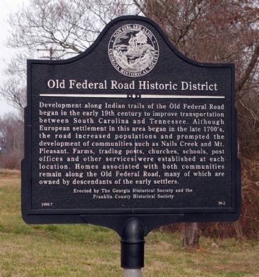
Old Federal Road Historic District
Erected 1999 by The Georgia Historical Society and the Franklin County Historical Society. (Marker Number 59-2.)
Topics and series. This historical marker is listed in these topic lists: Native Americans • Roads & Vehicles • Settlements & Settlers. In addition, it is included in the Georgia Historical Society series list.
Location. 34° 20.831′ N, 83° 18.487′ W. Marker is in Carnesville, Georgia, in Franklin County. Marker is on Georgia Route 59, ¼ mile north of Sandy Cross Road (Georgia Route 51), on the right when traveling north. Touch for map. Marker is in this post office area: Carnesville GA 30521, United States of America. Touch for directions.
Other nearby markers. At least 8 other markers are within 9 miles of this marker, measured as the crow flies. Franklin County (approx. 4.4 miles away); Hebron Presbyterian Church (approx. 4½ miles away); Cromer's Mill Covered Bridge (approx. 5½ miles away); Carroll's Methodist Church (approx. 5.8 miles away); Nails Creek Baptist Church (approx. 5.8 miles away); Red Hill School (approx. 6.7 miles away); Mt. Pleasant Church (approx. 7.8 miles away); a different marker also named Carroll’s Methodist Church (approx. 9 miles away). Touch for a list and map of all markers in Carnesville.
Credits. This page was last revised on January 26, 2020. It was originally submitted on January 3, 2009, by David Seibert of Sandy Springs, Georgia. This page has been viewed 1,607 times since then and 33 times this year. Photo 1. submitted on January 3, 2009, by David Seibert of Sandy Springs, Georgia. • Kevin W. was the editor who published this page.
Editor’s want-list for this marker. A wide shot of the marker and its surroundings. • Can you help?
