Red Hill in Franklin County, Georgia — The American South (South Atlantic)
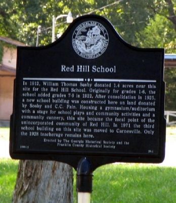
Red Hill School
Erected 1999 by The Georgia Historical Society and the Franklin County Historical Society. (Marker Number 59-1.)
Topics and series. This historical marker is listed in this topic list: Education. In addition, it is included in the Georgia Historical Society series list. A significant historical year for this entry is 1912.
Location. 34° 26.108′ N, 83° 15.638′ W. Marker is in Red Hill, Georgia, in Franklin County. Marker is at the intersection of Georgia Route 106 and Red Hill School Road, on the left when traveling west on State Route 106. Touch for map. Marker is in this post office area: Carnesville GA 30521, United States of America. Touch for directions.
Other nearby markers. At least 8 other markers are within 10 miles of this marker, measured as the crow flies. Franklin County (approx. 4.7 miles away); Red Hollow Road (approx. 5˝ miles away); Stephens County High School (approx. 6 miles away); Carroll's Methodist Church (approx. 6 miles away); Old Federal Road Historic District (approx. 6.7 miles away); Double Branches Baptist Church (approx. 7.8 miles away); a different marker also named Carroll’s Methodist Church (approx. 7.8 miles away); Poplar Springs Methodist Camp Ground (approx. 9.3 miles away).
Credits. This page was last revised on January 3, 2020. It was originally submitted on January 10, 2009, by David Seibert of Sandy Springs, Georgia. This page has been viewed 1,105 times since then and 28 times this year. Photo 1. submitted on January 10, 2009, by David Seibert of Sandy Springs, Georgia. • Kevin W. was the editor who published this page.
Editor’s want-list for this marker. A wide shot of the marker and its surroundings. • Can you help?
