Near Glen Allen in Henrico County, Virginia — The American South (Mid-Atlantic)
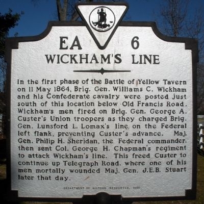
Wickham's Line
Erected 1996 by Department of Historic Resources. (Marker Number EA-6.)
Topics and series. This historical marker is listed in this topic list: War, US Civil. In addition, it is included in the Virginia Department of Historic Resources (DHR) series list. A significant historical date for this entry is May 11, 1864.
Location. 37° 40.044′ N, 77° 28.033′ W. Marker is near Glen Allen, Virginia, in Henrico County. Marker is at the intersection of Virginia Center Parkway and Holliman Drive, on the right when traveling south on Virginia Center Parkway. The marker is located inside a residential area playground. Touch for map. Marker is in this post office area: Glen Allen VA 23059, United States of America. Touch for directions.
Other nearby markers. At least 8 other markers are within 2 miles of this marker, measured as the crow flies. Stuart’s Mortal Wound (approx. 0.6 miles away); Battle of Yellow Tavern (approx. 0.6 miles away); a different marker also named Stuart’s Mortal Wound (approx. 0.6 miles away); Major General James Ewell Brown Stuart (approx. 0.9 miles away); Yellow Tavern (approx. 0.9 miles away); Virginia Estelle Randolph (approx. 0.9 miles away); Anderson Cemetery (approx. 1.2 miles away); Liberty Golden Eagle (approx. 1.2 miles away). Touch for a list and map of all markers in Glen Allen.
Credits. This page was last revised on June 16, 2016. It was originally submitted on February 4, 2009, by Bernard Fisher of Richmond, Virginia. This page has been viewed 1,558 times since then and 22 times this year. Photos: 1, 2. submitted on February 4, 2009, by Bernard Fisher of Richmond, Virginia. • Craig Swain was the editor who published this page.

