Cumberland Township near Gettysburg in Adams County, Pennsylvania — The American Northeast (Mid-Atlantic)
Battlefield Landmarks - West and North
July 3, 1863 - Third Day
Lt. Col. Franklin Sawyer, U.S.A.
8th Ohio Infantry
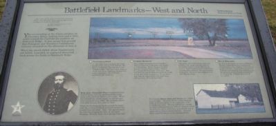
You are standing at the Union position on Cemetery Ridge, looking west and a little north toward the Confederate position on Seminary Ridge. It was across this ground that Pettigrew and Trimble's Confederate infantry attacked on the afternoon of July 3.
When the attack failed, those Southerners not killed, wounded, or captured streamed back across the fields to Seminary Ridge.
(Numbered points indicated on the panoramic photograph):
(1) Emmitsburg Road
In 1863 this was a sunken, dirt road bordered by post-and-rail fences. On July 3, attacking Confederates were forced to either tear the fences down or climb over them, exposing themselves to the murderous fire of Union musketry and artillery.
(2) Virginia Memorial
This elegant memorial was erected in 1917 to honor all Virginians who fought at Gettysburg. Above the granite base stands a bronze figure of Gen. Robert E. Lee astride his horse "Traveler." Lee watched the attack from the point of woods to the left of the monument. It was here also that he consoled his defeated men, telling them, "It is all my fault."
(3) The Angle
This place where two stone walls join to form a 90° angle was the scene of desperate hand-to-hand fighting on July 3. Some Confederates succeeded in crossing the wall here, but were unable to prevail. Veterans remembered it as the "Bloody Angle."
(4) Site of Bliss Farm
On July 2, the house and farm of William Bliss provided shelter for Confederate sharpshooters who sniped at Union troops positioned here. Tired of this annoyance, Federals assaulted the farm buildings on the morning of July 3 and burned them to the ground. William Bliss lost all he owned.
Erected by Gettysburg National Military Park.
Topics. This historical marker is listed in this topic list: War, US Civil. A significant historical date for this entry is July 3, 1863.
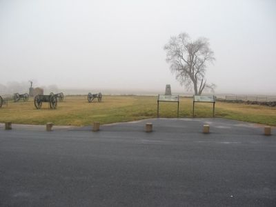
Location. This marker has been replaced by another marker nearby. It was located near 39° 48.802′ N, 77° 14.131′ W. Marker was near Gettysburg, Pennsylvania, in Adams County. It was in Cumberland Township. Marker was on Hancock Avenue, on the left when traveling north. Located in front of "the Angle" on Cemetery Ridge in Gettysburg National Military Park. Touch for map. Marker was in this post office area: Gettysburg PA 17325, United States of America. Touch for directions.
Other nearby markers. At least 8 other markers are within walking distance of this location. The Aftermath (here, next to this marker); Defining Moments (here, next to this marker);
Gettysburg Cyclorama (a few steps from this marker); Arnold's Battery (a few steps from this marker); Army of the Potomac (a few steps from this marker); Artillery Brigade (a few steps from this marker); Twenty-Sixth North Carolina Regiment (within shouting distance of this marker); Fourth Volunteer Brigade (within shouting distance of this marker). Touch for a list and map of all markers in Gettysburg.
More about this marker. In the lower center is a portrait of General Hays. Brig. Gen. Alexander Hays commanded four lines of Union infantry positioned behind the stone wall and Brian Barn to your right. When the Confederate attack began, he had his men clean and load extra rifles. He occupied others with drill, leaving little time for fear.
When Confederate ranks neared the stone wall, the waiting Federals poured a murderous musket fire into them. Hays rode up and down the line encouraging his men, at one point shouting, "Harrah, boys, we're giving them hell."
On the lower right is a photo of the Brian farm. The historic Brian barn and house are visible to your right.
Abraham Brian, a free black in 1863, fled Gettysburg at the approach of the Confederate army. During Pettigrew's attack on July 3, Mississippians of Davis' Brigade used the barn for cover until they were driven out or captured by Union reinforcements. General Hays used the house as his headquarters.
Related marker. Click here for another marker that is related to this marker. New Marker At This Location titled "Defining Moments".
Credits. This page was last revised on February 7, 2023. It was originally submitted on February 12, 2009, by Craig Swain of Leesburg, Virginia. This page has been viewed 1,233 times since then and 32 times this year. Photos: 1, 2. submitted on February 12, 2009, by Craig Swain of Leesburg, Virginia. 3. submitted on March 29, 2009, by Craig Swain of Leesburg, Virginia.


