Fort Seneca in Seneca County, Ohio — The American Midwest (Great Lakes)
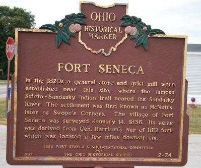
Fort Seneca
Erected 1987 by 1986 Fort Seneca Sesqui-Centennial Committee and The Ohio Historical Society. (Marker Number 2-74.)
Topics and series. This historical marker is listed in these topic lists: Forts and Castles • Native Americans • Settlements & Settlers • War of 1812. In addition, it is included in the Ohio Historical Society / The Ohio History Connection series list. A significant historical date for this entry is January 14, 1775.
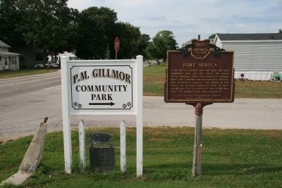
Location. 41° 12.558′ N, 83° 10.049′ W. Marker is in Fort Seneca, Ohio, in Seneca County. Marker is at the intersection of Fremont-Tiffin Road (Ohio Route 53) and Township Road 1020 on Fremont-Tiffin Road. Touch for map. Marker is at or near this postal address: 5865 Fremont-Tiffin Rd, Tiffin OH 44883, United States of America. Touch for directions.
Other nearby markers. At least 8 other markers are within 4 miles of this marker, measured as the crow flies. to Brady's Island / to Battle Island (here, next to this marker); Native American Habitation (approx. 1.2 miles away); Pleasant Township Civil War Memorial (approx. 1.7 miles away); Old Fort High School World War II Memorial (approx. 2 miles away); Fort Seneca - Harrison Trail (approx. 2.2 miles away); P.M. Gilmor Old Fort Bridge (approx. 2.3 miles away); Old Fort Centennial Park (approx. 2.3 miles away); Mull Covered Bridge / Covered Bridges (approx. 3.7 miles away).
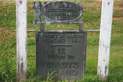
More about this marker. This marker is located adjacent to another historical marker from the old "Ohio Revolutionary Memorial Trail" series. The marker makes note of the "Harrison-Shelby Marches" of 1813, which would have occurred along the Scioto-Sandusky Trail mentioned on the "Fort Seneca" marker.
Related markers. Click here for a list of markers that are related to this marker. To better understand the relationship, study each marker in the order shown.
Credits. This page was last revised on June 16, 2016. It was originally submitted on April 20, 2009, by Dale K. Benington of Toledo, Ohio. This page has been viewed 1,691 times since then and 47 times this year. Photos: 1, 2, 3. submitted on April 20, 2009, by Dale K. Benington of Toledo, Ohio. • Kevin W. was the editor who published this page.


