Near Boaz in Richland County, Wisconsin — The American Midwest (Great Lakes)
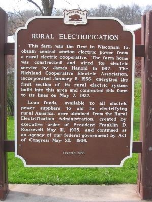
Rural Electrification
Loan funds, available to all electric power suppliers to aid in electrifying rural America, were obtained from the Rural Electrification Administration, created by executive order of President Franklin D. Roosevelt May 11, 1935, and continued as an agency of our federal government by Act of Congress May 20, 1936.
Erected 1966 by the Wisconsin Historical Society. (Marker Number 153.)
Topics and series. This historical marker is listed in this topic list: Notable Events. In addition, it is included in the Rural Electrification 💡, and the Wisconsin Historical Society series lists. A significant historical date for this entry is May 7, 1937.
Location. 43° 20.583′ N, 90° 30.236′ W. Marker is near Boaz, Wisconsin, in Richland County. Marker is on U.S. 14, 0.7 miles east of County Highway Z. Marker is at a highway pull-off. Touch for map. Marker is in this post office area: Richland Center WI 53581, United States of America. Touch for directions.
Other nearby markers. At least 8 other markers are within 10 miles of this marker, measured as the crow flies. Boaz Mastodon (a few steps from this marker); Richard M. Brewer (approx. 1.3 miles away); Ocooch Mountains (approx. 1.3 miles away); Wisconsin Purple Heart Memorial Highway (approx. 5˝ miles away); Ada James (approx. 5.8 miles away); Krouskop Park (approx. 5.8 miles away); Birthplace of GTE (approx. 5.8 miles away); The Little Rock (approx. 10 miles away). Touch for a list and map of all markers in Boaz.
Credits. This page was last revised on January 6, 2018. It was originally submitted on May 12, 2009, by Keith L of Wisconsin Rapids, Wisconsin. This page has been viewed 1,453 times since then and 44 times this year. Photos: 1, 2, 3. submitted on May 12, 2009, by Keith L of Wisconsin Rapids, Wisconsin. • Bill Pfingsten was the editor who published this page.


