Coalinga in Fresno County, California — The American West (Pacific Coastal)
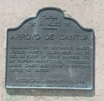
Arroyo de Cantua
14 Miles
Headquarters of notorious bandit, Joaquin Murieta. Killed here July 25, 1853, by posse of State Rangers, led by Captain Harry Love. Terrorized mining camps and stage operations during his career.
Erected by Department of Public Works - Division of Highways. (Marker Number 344.)
Topics and series. This historical marker is listed in these topic lists: Hispanic Americans • Industry & Commerce • Law Enforcement • Roads & Vehicles. In addition, it is included in the California Historical Landmarks series list. A significant historical month for this entry is July 1805.
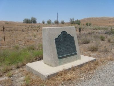
Location. 36° 14.789′ N, 120° 18.892′ W. Marker is in Coalinga, California, in Fresno County. Marker is on Dorris Avenue (State Highway 198) 0.1 miles east of State Highway 33, on the left when traveling east. Marker is located 9 miles north of Coalinga. Touch for map. Marker is at or near this postal address: 32400 Dorris Avenue, Coalinga CA 93210, United States of America. Touch for directions.
Other nearby markers. At least 8 other markers are within 8 miles of this marker, measured as the crow flies. A different marker also named Arroyo de Cantua (approx. 0.2 miles away); Harry S. Watanabe (approx. 6.8 miles away); “Wooden Walking Beam” (approx. 6.8 miles away); Coalinga Union High School (approx. 7.6 miles away); Motte Fountain (approx. 7.6 miles away); Bob’s 76 Service (approx. 7.6 miles away); Coalinga Carnegie Library (approx. 7.7 miles away); Grammar School (approx. 7.7 miles away). Touch for a list and map of all markers in Coalinga.
Regarding Arroyo de Cantua. An identical marker is located on Highway 33, 0.1 mile south of Dorris Ave.
This site was designated as California Registered Historical Landmark No. 344 on August 8, 1939.
Statement of Significance:
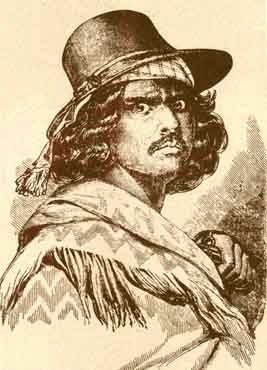
This was said to be the headquarters of notorious bandit Joaquin Murieta who made a career of terrorizing mining camps and stage operations. He was killed here July 25, 1853 by a posse of State Rangers led by Captain Harry Love.
Also see . . . California Rangers kill Joaquin Murrieta. History website entry (Submitted on February 29, 2024, by Larry Gertner of New York, New York.)
Additional commentary.
1. Murrieta vs Captain Harry Love – The Severed Head
An Article by Mary Trotter Kion, June 1, 2006
Joaquin Murrietta continues his outrageous outlaw life until Captain Harry Love, a noted Los Angles gunfighter, steps in to rectify the situation and heads rolled.
The Earth Shakes and Heads Roll
Joaquin met his match, or so it's said but not believed by all, when Captain Harry Love, a noted Los Angeles gunfighter, decided to make a more celebrated name for himself. One day Love, with 20 men at his back, rode down on the Mexican bandits. Love surprised the Murrieta gang as they languished around their campfire near Lake Tulare.
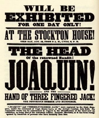
The outcome of this 1854 confrontation was that Murrieta was not only captured but also got his head severed. After the bloody ruckus a man by the name of Billy Henderson presented the sheriff with a gunnysack containing some Mexican's head and claiming it to be Murrieta's. Now Murrieta actually had a price on his head when, in good old California mining camp style, the severed head was put up for auction. It went to the highest bidder for thirty-five dollars.
Joaquin Murrietta's head, confined to a large jar of alcohol, went on display in the old Gordon Museum on Market Street, in San Francisco. For the grand sum of twenty-five cents the curious could gaze to their heart's content. But even in death, and with a severed head or missing body, depending on how you look at it, Joaquin Murrieta made his great escape from the confines of the law.
The big glass jar jail break came in 1906 when Mother Earth decided to shake and tremble, bring that City by the Bay to its crumbling and burning earth-quaking knees. In the ruckus and disaster, Murrieta's head disappeared for all time.
Source: http://americanhistory.suite101.com/article.cfm/joaquin_murrietta_4
— Submitted June 20, 2009.
2. Love/Murietta Site
Two scenarios abound re: the deaths/shoot out involving a group of Mexican horsemen in July 1853 with Capt Love's Rangers.
One states Capt Love found them near Panoche Pass - a distinct area in San Benito County. A second states Capt Love found them near Arroyo de Cantua (near Coalinga) in Fresno County. The latter has a state marker to that effect. The distance between these two spots in not 14 miles (as listed on the marker) but some 35-40 miles as the crow flies. Why this conudrum in listing the two sites? Also, is there a marker near Panoche Pass?
Editors Note: There are many reports of Joaquin Murrieta and his gang. These include his activities, his relationships, and of his reported death at the hands of Captain Love and the Rangers. Many of these sources were from articles written by the newspaper reports of the day, and many of those articles were based on interviews, rumors, and assumptions. There are conflicting reports in many articles which contribute to the confusion.
As to the actual site of the Murrieta killing this may one of those events of which the true story is lost to history forever. Note To Editor only visible by Contributor and editor
— Submitted October 16, 2010, by Wayne Padgett of Daly City, Ca..
Credits. This page was last revised on February 29, 2024. It was originally submitted on June 20, 2009, by Syd Whittle of Mesa, Arizona. This page has been viewed 3,887 times since then and 147 times this year. Last updated on July 29, 2023, by Ronald D. (Ron) Trigueiro of Fresno, California. Photos: 1. submitted on June 20, 2009, by Syd Whittle of Mesa, Arizona. 2, 3, 4. submitted on June 21, 2009, by Syd Whittle of Mesa, Arizona. • Bill Pfingsten was the editor who published this page.


