Near Burkittsville in Frederick County, Maryland — The American Northeast (Mid-Atlantic)
“Sealed With Their Lives”
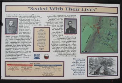
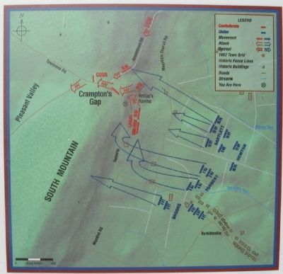
Just before the Confederate line along Mountain Church Road gave way, Brigadier General Howell Cobb arrived in Crampton’s Gap with his Georgia and North Carolina troops. After meeting with Colonel Thomas Munford, who had been directing the battle, Cobb allowed Munford to deploy Cobb’s troops. Munford ordered the 15th North Carolina to the Arnoldstown Road. There they took a position behind a stone wall facing Whipp’s Ravine. The 24th Georgia was ordered into the ravine while Cobb’s Legion followed by the 16th Georgia, moved down Gapland Road. Near here Cobb’s Legion formed line of battle on the mountain slope about halfway down between the two roads, the 16th Georgia to its left. As remnants of Munford’s shattered line rushed through the Legion’s ranks, Torbert’s New Jersey Brigade surrounded it on three sides, the 3rd New Jersey wheeling down onto the Legion from behind after climbing to Gapland Road unopposed.
Twelve hundred New Jersey soldiers surrounded the 248 men of Cobb’s Legion. If Lieutenant Colonel Jefferson Lamar, the Legion’s commander, retreated, he might start a stampede of the entire Confederate line; but, if he stayed where he was, he might buy time for the rest of the Confederates to retreat. He chose to stay. Shortly after, a bullet smashed into his leg, toppling him to the ground. Eventually, Captain William Lowe of Company F, also wounded in the leg, called to Lamar that the Legion was being annihilated. Lowe helped Lamar to his feet so he could order the Legion out of the killing field. No sooner had Lamar done so than a bullet tore through his chest, mortally wounding him. In about twenty minutes, the Legion sustained 72% casualties—killed, wounded, and missing.
Brig. Gen. Howell Cobb
16th Ga., 24th Ga., Cobb’s Legion, 15th N.C.
Brig. Gen. Paul J. Semmes
10th Ga.
Col. Thomas T. Munford
2nd Va. Cav., 12th Va. Cav., Chew’s Battery
Col. William A. Parham
6th Va., 12th Va., 16th Va., Portsmouth Light Arty.
United States of America
Maj. Gen. William B. Franklin, VI Corps
Maj. Gen. Henry W. Slocum
Col. Torbert
1st N.J., 2nd N.J., 3rd N.J., 4th N.J.
Col. Bartlett
27th N.Y. 16th N.Y., 5th Me., 96th Pa.
Brig. Gen. Newton
18th N.Y., 31st N.Y., 32nd N.Y., 95th Pa.
Maj. Gen. William F. (Baldy) Smith
Brig. Gen. Brooks
2nd Vt., 3rd Vt. (nc), 4th Vt., 5th Vt. (nc), 6th Vt (nc)
(nc) noncombatants
Donated to the citizens of the United States in honor of our ancestor, Private James Anderson Coker, 24th Georgia Volunteers, by Keith C. O'Neil & family.
Erected by Blue and Gray Educational Society.
Topics. This historical marker is listed in this topic list: War, US Civil.
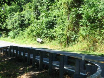
Location. 39° 24.087′ N, 77° 38.27′ W. Marker is near Burkittsville, Maryland, in Frederick County. Marker is on Gapland Road, on the right when traveling south. Touch for map. Marker is in this post office area: Burkittsville MD 21718, United States of America. Touch for directions.
Other nearby markers. At least 8 other markers are within walking distance of this marker. Chew’s Ashby Artillery (here, next to this marker); Burkittsville: Henry Burkitt’s Town (here, next to this marker); Gath's Empty Tomb (approx. ¼ mile away); Mausoleum (approx. ¼ mile away); The Confusion of Battle (approx. ¼ mile away); The 15th North Carolina (approx. ¼ mile away); Brownsville Pass: Semmes’ Gamble (approx. ¼ mile away); GATH: The Man and His Mountain (approx. ¼ mile away). Touch for a list and map of all markers in Burkittsville.
More about this marker. Flanking the text are portraits of General Cobb and Colonel Lamar. A map depicts unit movements described in the text. A newspaper drawing carries the caption “This engraving appeared in Harper’s Weekly on October 15, 1862. It probably depicts the defense of Cobb’s Legion against Torbert’s New Jersey Brigade.”
Related marker. Click here for another marker that is related to this marker. Cobb’s
Brigade McLaw’s Division C.S.A.
Credits. This page was last revised on February 28, 2022. It was originally submitted on August 13, 2007, by Craig Swain of Leesburg, Virginia. This page has been viewed 2,006 times since then and 28 times this year. Photos: 1, 2, 3, 4. submitted on August 13, 2007, by Craig Swain of Leesburg, Virginia. • J. J. Prats was the editor who published this page.


