Olde Towne in Portsmouth, Virginia — The American South (Mid-Atlantic)
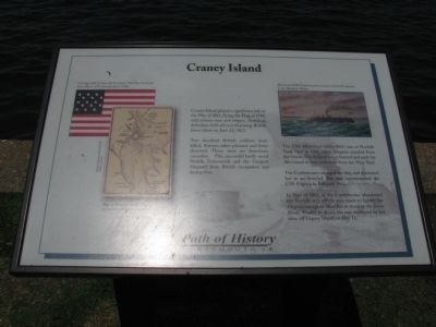
Craney Island
Two hundred British soldiers were killed, thirteen taken prisoner and forty deserted. There were no American casualties. This successful battle saved Norfolk, Portsmouth and the Gosport Shipyard from British occupation and destruction.
The USS Merrimack (1856 – 1861) was at Norfolk Navy Yard in 1861, when Virginia seceded from the Union. The Federal forces burned and sank the Merrimack as they withdrew from the Navy Yard.
The Confederates salvaged the ship and converted her to an ironclad. She was commissioned the CSS Virginia in February 1862.
In May of 1862, as the Confederates abandoned the Norfolk area, efforts were made to lighten the Virginia enough to allow her to move up the James River. Unable to do so, she was destroyed by her crew off Craney Island on May 11.
Topics. This historical marker is listed in these topic lists: War of 1812 • War, US Civil • Waterways & Vessels. A significant historical month for this entry is May 1862.
Location. 36° 50.429′ N, 76° 18.073′ W. Marker is in Portsmouth, Virginia . It is in Olde Towne. Marker is on Crawford Parkway west of Court Street, on the right. This marker is part of the Portsmouth, VA Path of History. Touch for map. Marker is in this post office area: Portsmouth VA 23704, United States of America. Touch for directions.
Other nearby markers. At least 8 other markers are within walking distance of this marker. Cornwallis at Portsmouth (within shouting distance of this marker); Arnold's British Defenses, 1781 (within shouting distance of this marker); Olde Towne Portsmouth (within shouting distance of this marker); Crawford Bay (within shouting distance of this marker); Fort Nelson (within shouting distance of this marker); Elks Lodge (approx. 0.2 miles away); Watts House (approx. 0.2 miles away); The Yellow Fever of 1855 (approx. 0.2 miles away). Touch for a list and map of all markers in Portsmouth.
Related marker. Click here for another marker that is related to this marker. Another marker about the Battle of Craney Island.
Credits. This page was last revised on February 1, 2023. It was originally submitted on July 26, 2009, by Kristin Rollins of Portsmouth, Virginia. This page has been viewed 1,352 times since then and 24 times this year. Photos: 1. submitted on July 26, 2009, by Kristin Rollins of Portsmouth, Virginia. 2. submitted on February 14, 2014, by Mike Wintermantel of Pittsburgh, Pennsylvania. • Craig Swain was the editor who published this page.

