Neon District in Norfolk, Virginia — The American South (Mid-Atlantic)
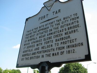
Fort Tar
Erected by City of Norfolk.
Topics. This historical marker is listed in these topic lists: Forts and Castles • War of 1812. A significant historical year for this entry is 1812.
Location. 36° 51.526′ N, 76° 17.221′ W. Marker is in Norfolk, Virginia. It is in the Neon District. Marker is on Monticello Avenue (U.S. 460) north of East Virginia Beach Boulevard (U.S. 58), on the right when traveling north. Touch for map. Marker is in this post office area: Norfolk VA 23510, United States of America. Touch for directions.
Other nearby markers. At least 8 other markers are within walking distance of this marker. West Point Cemetery (about 800 feet away, measured in a direct line); a different marker also named West Point Cemetery (approx. 0.2 miles away); West Point Monument (approx. 0.2 miles away); West Point Monument at Elmwood Cemetery (approx. 0.2 miles away); Elmwood Cemetery (approx. ¼ mile away); a different marker also named Elmwood Cemetery (approx. 0.3 miles away); Cedar Grove Cemetery (approx. 0.3 miles away); AKA Iota Omega (approx. 0.4 miles away). Touch for a list and map of all markers in Norfolk.
Credits. This page was last revised on February 1, 2023. It was originally submitted on July 28, 2009, by Kristin Rollins of Portsmouth, Virginia. This page has been viewed 2,077 times since then and 87 times this year. Photo 1. submitted on July 28, 2009, by Kristin Rollins of Portsmouth, Virginia. • Kevin W. was the editor who published this page.
