Riddleville in Washington County, Georgia — The American South (South Atlantic)
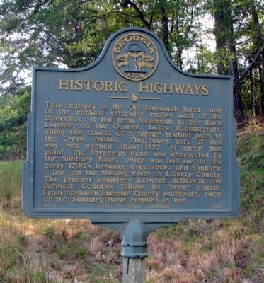
Historic Highways
Erected 1956 by Georgia Historical Commission. (Marker Number 150-10.)
Topics and series. This historical marker is listed in these topic lists: Native Americans • Roads & Vehicles • Settlements & Settlers. In addition, it is included in the Georgia Historical Society series list. A significant historical year for this entry is 1777.
Location. 32° 52.365′ N, 82° 34.513′ W. Marker is in Riddleville, Georgia, in Washington County. Marker is on Bartow Road (Georgia Route 242 at milepost 19), 0 miles west of Dublin Bartow Road, on the right when traveling east. Touch for map. Marker is in this post office area: Bartow GA 30413, United States of America. Touch for directions.
Other nearby markers. At least 8 other markers are within 6 miles of this marker, measured as the crow flies. Tarver's Mill (approx. 3.2 miles away); New Hope Methodist Church (approx. 4.3 miles away); Old Sunbury Road (approx. 5.2 miles away); Old Savannah Road (approx. 5.6 miles away); Claxton Historic Burial Site (approx. 5.8 miles away); Riddleville (approx. 5.8 miles away); Bartow (approx. 5.9 miles away); Site of Fort Wood (approx. 5.9 miles away).
Credits. This page was last revised on February 1, 2020. It was originally submitted on July 30, 2009, by David Seibert of Sandy Springs, Georgia. This page has been viewed 871 times since then and 17 times this year. Photo 1. submitted on July 30, 2009, by David Seibert of Sandy Springs, Georgia. • Craig Swain was the editor who published this page.
Editor’s want-list for this marker. A wide shot of the marker and its surroundings. • Can you help?
