Gardner in Johnson County, Kansas — The American Midwest (Upper Plains)
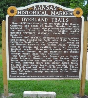
Overland Trails
Between 1840 and 1870 thousands of settlers, miners, and soldiers plodded the 2,000 miles of the Oregon-California Trail from the "jumping off" towns on the Missouri River to the Pacific Ocean. Diseases such as cholera and smallpox were the travelers' greatest enemies. Unknown thousands of emigrants died from disease, as did many of the Indians through whose lands they traveled.
The Santa Fe Trail was famous as a freight route between Missouri and New Mexico. Pack trains undertook the difficult journey as early as 1821, following rivers and earlier Indian trails. By 1825, large wagon trains were carrying tons of goods both east and west. US-56 generally follows the old trail route southwestward across Kansas some 500 miles, nearly two-thirds of the trail's total length.
Erected by Kansas State Historical Society and Kansas Department of Transportation. (Marker Number 6.)
Topics and series. This historical marker is listed in these topic lists: Exploration • Roads & Vehicles • Settlements & Settlers. In addition, it is included in the California Trail, the Kansas Historical Society, the Oregon Trail, the Overland Trail, and the Santa Fe Trail series lists. A significant historical year for this entry is 1840.
Location. 38° 48.688′ N, 94° 55.898′ W. Marker is in Gardner, Kansas, in Johnson County. Marker is on Main Street, 0.1 miles North Oak Street, on the right when traveling west. Touch for map. Marker is at or near this postal address: 204 West Main Street, Gardner KS 66030, United States of America. Touch for directions.
Other nearby markers. At least 8 other markers are within walking distance of this marker. The Herman B. Foster Home (within shouting distance of this marker); Dodge Sisters' Millinery Shop (approx. 0.3 miles away); Site of the first Furniture Store and Undertaker (approx. 0.3 miles away); Farmers Bank (approx. 0.3 miles away); Gardner State Bank Building (approx. 0.4 miles away); The Gardner Gazette (approx. 0.4 miles away); Site of Bigelow-Foster Mercantile (approx. 0.4 miles away); Site of First General Store (approx. 0.4 miles away). Touch for a list and map of all markers in Gardner.
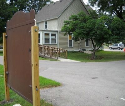
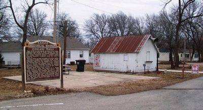
More about this marker. This Kansas State Historical marker was originally located in a small wayside park about 2 miles SW of town. A new park was put in and this marker was recently moved to this location at the Gardner Historical Museum parking lot.
Also see . . .
1. Santa Fe National Historical Trail. Take a journey between western Missouri and Santa Fe on the Santa Fe National Historic Trail. (Submitted on August 15, 2009, by Thomas Onions of Olathe, Kansas.)
2. Kansas Historical Markers. The official link for the Kansas State Historical Society on the Official Kansas roadside markers. (Submitted on August 15, 2009, by Thomas Onions of Olathe, Kansas.)
3. Legends of America. History, Information, Maps, etc., of the Santa Fe Trail. (Submitted on August 15, 2009, by Thomas Onions of Olathe, Kansas.)
4. Map of Oregon Trail. (Submitted on August 15, 2009, by Thomas Onions of Olathe, Kansas.)
5. Mileposts Along the Oregon Trail. (Submitted on August 15, 2009, by Thomas Onions of Olathe, Kansas.)
6. Oregon National Historic Trail. This is the Official link from the National Park Service. (Submitted on August 15, 2009, by Thomas Onions of Olathe, Kansas.)
7. California Historic Trail. This is the Official National Park Service Link to the California Trail. (Submitted on August 15, 2009, by Thomas Onions of Olathe, Kansas.)
8. Gardner Historical Museum. Link to the Musuem where the marker is located. (Submitted on August 15, 2009, by Thomas Onions of Olathe, Kansas.)
Additional keywords. Santa Fe Trail Oregon Trail California Trail
Credits. This page was last revised on January 22, 2021. It was originally submitted on August 15, 2009, by Thomas Onions of Olathe, Kansas. This page has been viewed 2,830 times since then and 75 times this year. Photos: 1, 2. submitted on August 15, 2009, by Thomas Onions of Olathe, Kansas. 3. submitted on February 14, 2016, by William Fischer, Jr. of Scranton, Pennsylvania. • Syd Whittle was the editor who published this page.


