Leesburg in Loudoun County, Virginia — The American South (Mid-Atlantic)
42nd New York Infantry
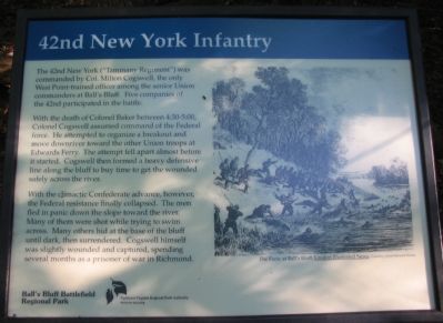
With the death of Colonel Baker between 4:30-5:00, Colonel Cogswell assumed command of the Federal force. He attempted to organize a breakout and move downriver toward the other Union troops at Edward’s Ferry. The attempt fell apart almost before it started. Cogswell then formed a heavy defensive line along the bluff to buy time to get the wounded safely across the river.
With the climactic Confederate advance, however, the Federal resistance finally collapsed. The men fled in panic down the slope toward the river. Many of them were shot while trying to swim across. Many others hid at the base of the bluff until dark, then surrendered. Cogswell himself was slightly wounded and captured, spending several months as a prisoner of war in Richmond.
Erected by Ball's Bluff Regional Park/Northern Virginia Regional Park Authority.
Topics and series. This historical marker is listed in this topic list: War, US Civil. In addition, it is included in the NOVA Parks series list.
Location. 39° 7.866′ N, 77° 31.655′ W. Marker is in Leesburg, Virginia, in Loudoun County. Marker can be reached from Ball’s Bluff Road, on the right when traveling east. Located at trail stop 8, inside Ball’s Bluff Regional Park. Touch for map. Marker is in this post office area: Leesburg VA 20175, United States of America. Touch for directions.
Other nearby markers. At least 8 other markers are within walking distance of this marker. 18th Mississippi Infantry (within shouting distance of this marker); 1st California Regiment (within shouting distance of this marker); Edward D. Baker (within shouting distance of this marker); Battle of Ball's Bluff - October 21, 1861: The Union Collapse (within shouting distance of this marker); Ball's Bluff National Cemetery (within shouting distance of this marker); a different marker also named Edward D. Baker (within shouting distance of this marker); a different marker also named Ball's Bluff National Cemetery (within shouting distance of this marker); United States National Military Cemetery (about 300 feet away, measured in a direct line). Touch for a list and map of all markers in Leesburg.
More about this marker. The marker displays a drawing, “The Panic at Ball’s Bluff,” London Illustrated News, Courtesy of Kim Bernard Holien.
Regarding 42nd New York Infantry. This marker is one of a set along the Balls Bluff Battlefield walking trail. See

Photographed By Craig Swain, July 30, 2007
2. The Old 42nd New York Infantry Marker
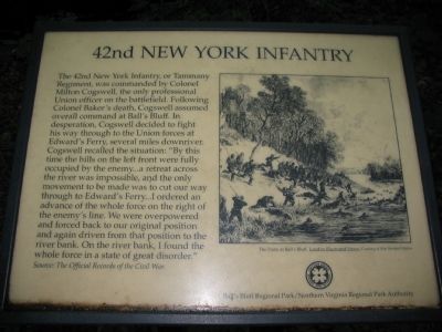
This old marker was replaced in August 2007. It read:
The 42nd New York Infantry, or Tammany Regiment, was commanded by Colonel Milton Cogswell, the only professional Union officer on the battlefield. Following Colonel Baker's death, Cogswell assumed overall command at Ball's Bluff. In desperation, Cogswell decided to fight his way through to the Union forces at Edward's Ferry, several miles downriver. Cogswell recalled the situation: "By this time the hills on the left front were fully occupied by the enemy...a retreat across the river was impossible, and the only movement to be made was to cut our way through to Edward's Ferry...I ordered an advance of the whole force on the right of the enemy's line. We were overpowered and forced back to our original position to the river bank. On the river bank, I found the whole force in a state of great disorder."
Source: The Official Records of the Civil War.
Credits. This page was last revised on October 4, 2020. It was originally submitted on August 31, 2007. This page has been viewed 1,550 times since then and 18 times this year. Last updated on October 4, 2020, by Bradley Owen of Morgantown, West Virginia. Photos: 1. submitted on September 1, 2007, by Craig Swain of Leesburg, Virginia. 2, 3, 4. submitted on August 31, 2007, by Craig Swain of Leesburg, Virginia. • J. Makali Bruton was the editor who published this page.


