Curtiss in Clark County, Wisconsin — The American Midwest (Great Lakes)
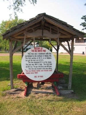
History of The Big White Pine
The tree measured 6 ft. on the stump. The tree was 144 ft. high. The first limb was 65 ft. up. The age of the tree is over 400 years.
This tree was located in the area where the Les Bowen family and friends have hunted since 1939.
Dec. of 1985
Erected 1985.
Topics. This historical marker is listed in this topic list: Landmarks. A significant historical month for this entry is December 1985.
Location. 44° 57.214′ N, 90° 26.063′ W. Marker is in Curtiss, Wisconsin, in Clark County. Marker is on North Meridian Street (County Highway E) south of West Front Street, on the left when traveling north. Marker is next to the United States Post Office in Curtiss. Touch for map. Marker is at or near this postal address: 915 North Meridian Street, Curtiss WI 54422, United States of America. Touch for directions.
Other nearby markers. At least 8 other markers are within 14 miles of this marker, measured as the crow flies. Veterans Memorial (within shouting distance of this marker); The Yellowstone Trail (about 600 feet away, measured in a direct line); S.S. Dorchester Memorial (approx. 6 miles away); Dorchester Veterans Memorial (approx. 6.3 miles away); The Home of Colby Cheese (approx. 6.6 miles away); Civilian Conservation Corps (approx. 13˝ miles away); United States Forest Service (approx. 13˝ miles away); Samuel Hartford (approx. 13.8 miles away). Touch for a list and map of all markers in Curtiss.
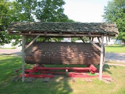
Related marker. Click here for another marker that is related to this marker. The first section of this log located in Glidden.
Also see . . . Yellowstone Trail. "The Yellowstone Trail was the first transcontinental automobile highway through the upper tier of states in the United States." (Submitted on September 9, 2009.)
Credits. This page was last revised on June 16, 2016. It was originally submitted on September 9, 2009, by Keith L of Wisconsin Rapids, Wisconsin. This page has been viewed 1,366 times since then and 16 times this year. Photos: 1, 2, 3. submitted on September 9, 2009, by Keith L of Wisconsin Rapids, Wisconsin. • Craig Swain was the editor who published this page.


