New Fairfield in Fairfield County, Connecticut — The American Northeast (New England)
New Fairfield
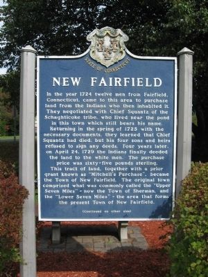
In the year 1724 twelve men from Fairfield, Connecticut , came to this area to purchase land from the Indians who then inhabited it. They negotiated with Chief Squantz of the Schaghticoke tribe, who lived near the pond in this town which still bears his name. returning in the spring of 1725 with the necessary documents, they learned that Chief Squantz had died, but his four sons and heirs refused to sign any deeds. Four years later, on April 24, 1729 the Indians finally deeded the land to the white men. The purchase price was sixty-five pounds sterling. This tract of land, together with a prior grant known as “Mitchell’s Purchase”, became the Town of New Fairfield. The original town comprised what was commonly called the “Upper Seven Miles” – now the Town of Sherman, and the “Lower Seven Miles” – the area that forms the present Town of New Fairfield.
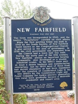
The town was incorporated in 1740, and the twelve “Proprietors” carried on civil affairs. When the first meeting house was built in 1742 by the South Society of New Fairfield (later known as the Congregational Church) it also served as the seat of government. In 1759 the civil government was separated from the Church and a town hall was built. During the early part of the 19th century, New Fairfield, always an important farming community, also developed as a sizable industrial center. In the 1860’s there were at least a dozen business and manufacturing enterprises, but by 1900 most of these firms had moved elsewhere or had been liquidated. After the creation of Candlewood Lake in the late 1920’s by the Connecticut Light and Power company for hydro-electric generation, this rural town gradually became a desirable residential and resort area.
Erected 1979 by Town of New Fairfield, New Fairfield Historical Society, Connecticut Historical Commission.
Topics. This historical marker is listed in these topic lists: Colonial Era • Settlements & Settlers. A significant historical month for this entry is April 1810.
Location. 41° 28.003′ N, 73° 29.224′ W. Marker is in New Fairfield, Connecticut, in Fairfield County. Marker is on Connecticut Route 37, 0.1 miles north of Brush Hill Road (Connecticut Route 39), on the left when traveling north. Touch for map. Marker is in this post office area: New Fairfield CT 06812, United States of America. Touch for directions.
Other nearby markers. At least 8 other markers are within 5 miles of this marker, measured as the crow flies. New Fairfield Veterans Memorial (within shouting distance of this marker); New Fairfield Fire Department Memorial (approx. 0.4 miles away); Col. H. Ludington (approx. 3.2 miles away in New York); DeForest Corners (approx. 3.6 miles away in New York); David Wooster Monument (approx. 4.7 miles away); Black Soldiers Memorial (approx. 4.8 miles away); Monument to Soldiers in Unknown Graves (approx. 4.8 miles away); Brookfield Veterans Monument (approx. 5.1 miles away). Touch for a list and map of all markers in New Fairfield.
Credits. This page was last revised on June 16, 2016. It was originally submitted on October 6, 2009, by Michael Herrick of Southbury, Connecticut. This page has been viewed 1,679 times since then and 57 times this year. Photos: 1, 2, 3. submitted on October 6, 2009, by Michael Herrick of Southbury, Connecticut. • Bill Pfingsten was the editor who published this page.


