Gainesville in Hall County, Georgia — The American South (South Atlantic)
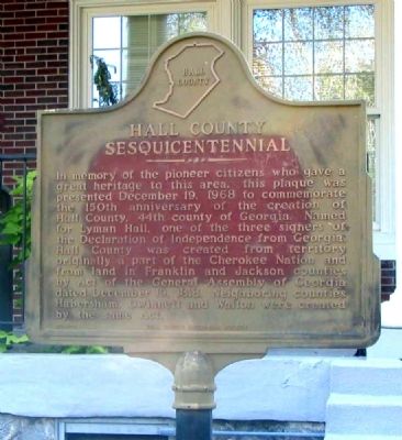
Hall County Sesquicentennial
Erected 1968 by Hall County Historical Society. (Marker Number HCHS-1.)
Topics. This historical marker is listed in these topic lists: Native Americans • Settlements & Settlers. A significant historical date for this entry is December 19, 1922.
Location. 34° 18.663′ N, 83° 49.625′ W. Marker is in Gainesville, Georgia, in Hall County. Marker is at the intersection of Green Street NE (Georgia Route 60) and Riverside Drive (U.S. 129), on the right when traveling north on Green Street NE. The marker is located at the front entrance to the Gainesville Civic Center. Touch for map. Marker is at or near this postal address: 830 Green Street NE, Gainesville GA 30501, United States of America. Touch for directions.
Other nearby markers. At least 8 other markers are within walking distance of this marker . Site of the Home of General James Longstreet (approx. ¼ mile away); Dr. Emmett Ethridge Butler (approx. 0.7 miles away); George Washington (approx. ¾ mile away); Federal Building (approx. ¾ mile away); The Historic Jackson Building (approx. ¾ mile away); First Private Mint / Templeton Reid Mint (approx. 0.8 miles away); Dedicated to the Veterans of 1898 - 1902 (approx. 0.8 miles away); U.D.C. Confederate Soldiers Monument (approx. 0.8 miles away). Touch for a list and map of all markers in Gainesville.
Also see . . . Hall County. The Wikipedia entry for Hall County. (Submitted on October 12, 2009, by David Seibert of Sandy Springs, Georgia.)
Credits. This page was last revised on January 30, 2020. It was originally submitted on October 10, 2009, by David Seibert of Sandy Springs, Georgia. This page has been viewed 923 times since then and 11 times this year. Photos: 1. submitted on October 10, 2009, by David Seibert of Sandy Springs, Georgia. 2, 3. submitted on December 23, 2009, by David Seibert of Sandy Springs, Georgia. • Craig Swain was the editor who published this page.


