Near Dawsonville in Dawson County, Georgia — The American South (South Atlantic)
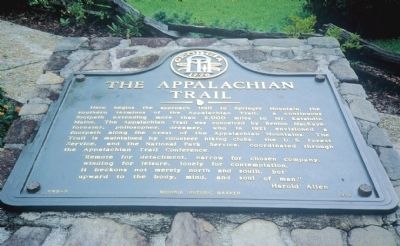
The Appalachian Trail
”Remote for detachment, narrow for chosen company, winding for leisure, lonely for contemplation, it beckons not merely north and south, but upward to the body, mind and soul of man.”Harold Allen
Erected 1976 by Georgia Department of Natural Resources. (Marker Number 042-2.)
Topics and series. This historical marker is listed in these topic lists: Environment • Horticulture & Forestry • Roads & Vehicles. In addition, it is included in the Georgia Historical Society series list. A significant historical year for this entry is 1921.
Location. 34° 33.474′ N, 84° 14.981′ W. Marker is near Dawsonville, Georgia, in Dawson County. Marker is at the intersection of Top of the Falls Road and Amicalola Park Road, on the right when traveling north on Top of the Falls Road. The marker is located in front of the Visitor Center at Amicalola Falls State Park. The Park is on Georgia Highway 52, northwest of Dawsonville. Touch for map. Marker is in this post office area: Dawsonville GA 30534, United States of America. Touch for directions.
Other nearby markers. At least 8 other markers are within 12 miles of this marker, measured as the crow flies. Springer Mountain (approx. 5.1 miles away); Ebenezer Baptist Church (approx. 7˝ miles away); Oakland Academy (approx. 9˝ miles away); Cartecay Methodist Church (approx. 10 miles away); Old Federal Road (approx. 11˝ miles away); Old Dawson County Jail (approx. 12 miles away); Pickens County (approx. 12 miles away); a different marker also named Old Federal Road (approx. 12 miles away).
Credits. This page was last revised on January 3, 2020. It was originally submitted on October 13, 2009, by David Seibert of Sandy Springs, Georgia. This page has been viewed 1,917 times since then and 40 times this year. Photos: 1. submitted on October 13, 2009, by David Seibert of Sandy Springs, Georgia. 2, 3. submitted on February 27, 2011, by David Seibert of Sandy Springs, Georgia. • Craig Swain was the editor who published this page.


