Watsonville in Santa Cruz County, California — The American West (Pacific Coastal)
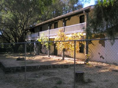
Rancho San Andrés Castro Adobe
Erected 1991 by State Office of Historic Preservation. (Marker Number 998.)
Topics and series. This historical marker is listed in these topic lists: Architecture • Settlements & Settlers • War, Mexican-American. In addition, it is included in the California Historical Landmarks series list.
Location. Marker has been reported missing. It was located near 36° 56.748′ N, 121° 48.66′ W. Marker was in Watsonville, California, in Santa Cruz County. Marker was on Old Adobe Road. The building can be seen from the road and is being restored, but is on Private Property with restricted public access. Please do not trespass. Touch for map. Marker was at or near this postal address: 184 Old Adobe Rd, Watsonville CA 95076, United States of America. Touch for directions.
Other nearby markers. At least 8 other markers are within 4 miles of this location, measured as the crow flies. Whiskey Hill (approx. 2.2 miles away); The Discovery of California Redwoods (approx. 2½ miles away); Charley Darkey Parkhurst (approx. 2.9 miles away); Donald Leon Rose (approx. 3 miles away); First High Altitude Airplane Flights March 1905 (approx. 3.1 miles away); Flying A Gas Station (approx. 3.1 miles away); Lest We Forget (approx. 3.4 miles away); St. Patricks Church (approx. 3.6 miles away). Touch for a list and map of all markers in Watsonville.
More about this marker. No State Historic Landmark plaque for this site is present.
Regarding Rancho San Andrés Castro Adobe. The building can be seen from the road and is being restored, but is on Private Property with restricted public access. Please do not trespass.
Credits. This page was last revised on November 8, 2019. It was originally submitted on September 7, 2007, by Mathew H. Kohnen of San Jose, California. This page has been viewed 4,023 times since then and 40 times this year. Photos: 1. submitted on September 9, 2007, by J. J. Prats of Powell, Ohio. 2. submitted on September 7, 2007, by Mathew H. Kohnen of San Jose, California. • J. J. Prats was the editor who published this page.
Editor’s want-list for this marker. Old photo of the plaque before it was removed • Can you help?

