Stratford Hills in Richmond, Virginia — The American South (Mid-Atlantic)
Pony Pasture Rapids
Captain John Smithís Adventures on the James
ó www.johnsmithtrail.org ó
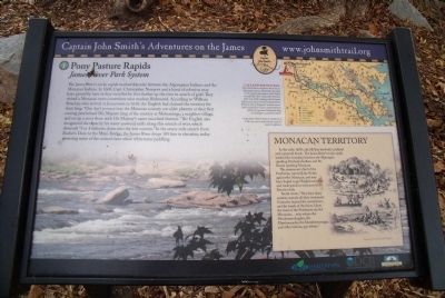
The James Riverís rocky rapids marked a border between the Algonquian Indians and the Monacan Indians. In 1608, Capt. Christopher Newport and a band of colonists may have passed by here as they travelled by foot further up the river in search of gold. They visited a Monacan town somewhere near modern Richmond. According to William Strachey, who arrived at Jamestown in 1610, the English had claimed the territory for their king: "One dayís journey into the Monacan country our elder planters at their first coming proclaimed His Majesty king of the country at Mohominge, a neighbor village, and set up a cross there with His Majestyís name inscribed thereon." The English recognized the capacity for water-powered mills along this stretch of river, which descends "3 or 4 fathoms down into the low country." In the seven-mile stretch from Bosherís Dam to the Mayo Bridge, the James River drops 105 feet in elevation, today powering some of the nationís best urban whitewater paddling.
Capt. John Smithís Trail
John Smith knew the James River by its Algonquian name: Powhatan, the same as the regionís paramount chief. Smith traveled the river many times between 1607 and 1609, trading with Virginia Indians to ensure survival at Jamestown. What he saw of Virginiaís verdant woodlands and pristine waters inspired him to explore the greater Chesapeake Bay, chronicling its natural wonders.
Capt John Smithís Trail on the James is a 40-site water and auto tour for modern explorers.
(sidebar)
Monacan Territory
In the early 1600ís, the fall line was both a cultural and a physical divide. The James Riverís rocky rapids marked the boundary between the Algonquian speaking Powhatans and the Siouan speaking Monacan.
The paramount chief of the Powhatans warned John Smith against the Monacan, and may have hoped to get English weapons and trade goods to overcome his historic rivals.
Smith wrote, “They have many enimies, namely all their westernely Countries beyond the mountains, and the heads of the rivers. Upon the head of the Powhatans are the MonacansÖunto whom the Mouhemenchughes, the Massinnacacks, the Monahassanuggs, and other nations, pay tributes.”
Erected by Captain John Smithís Trail, James River Association, Virginia Department of Conservation and Recreation, Chesapeake Bay Gateways Network. (Marker Number 1.)
Topics. This historical marker is listed in these topic lists: Colonial Era • Exploration • Native Americans • Waterways & Vessels. A significant historical year for this entry is 1608.
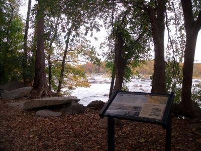
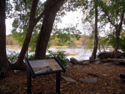
Location. 37° 33.088′ N, 77° 31.235′ W. Marker is in Richmond, Virginia. It is in Stratford Hills. Marker can be reached from Riverside Drive, 0.1 miles north of Rockfalls Drive. This panel is located at the north end of the Pony Pasture parking area in James River Park. Touch for map. Marker is in this post office area: Richmond VA 23225, United States of America. Touch for directions.
Other nearby markers. At least 8 other markers are within 2 miles of this marker, measured as the crow flies. Granite and History (about 400 feet away, measured in a direct line); Wilton (approx. 0.8 miles away); Windsor (approx. 1.1 miles away); Ampthill (approx. 1.2 miles away); a different marker also named Wilton (approx. 1.2 miles away); Richmond Defences (approx. 1.2 miles away); Intermediate Line of Confederate Defenses (approx. 1.2 miles away); Three-Chopt Road (approx. 1.3 miles away). Touch for a list and map of all markers in Richmond.
More about this marker. On the lower left is a photo of the Falls of the James.
On the upper right is a map of Captain John Smith's Trail.
The sidebar shows a sketch of Native Americans hunting at the fall line. Courtesy of the Library of Virginia.
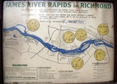
Regarding Pony Pasture Rapids. Pony Pasture Rapids is located on the south bank two miles downstream from the Huguenot Bridge on Riverside Drive. Fishing is excellent at this point and this area is considered to be one of Richmondís best locations for bird watching and inner tubing. An easy whitewater canoe run begins here and ends at the visitor center.
Also see . . .
1. Captain John Smithís Trail. (Submitted on October 27, 2009.)
2. Friends of the James River Park. (Submitted on October 27, 2009.)
Credits. This page was last revised on February 1, 2023. It was originally submitted on October 27, 2009, by Bernard Fisher of Richmond, Virginia. This page has been viewed 1,711 times since then and 33 times this year. Photos: 1, 2, 3, 4. submitted on October 27, 2009, by Bernard Fisher of Richmond, Virginia.


