Coltons Point in St. Mary's County, Maryland — The American Northeast (Mid-Atlantic)
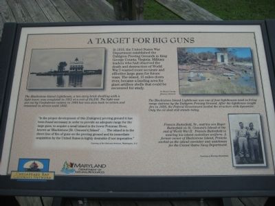
A Target for Big Guns
"In the proper development of this [Dahlgren] proving ground it has been found necessary in order to provide an adequate range for the large guns, to acquire a small island in the lower Potomac River, known as 'Blackistone [St. Clement's] Island'....The island is in the direct line of fire of guns on the proving ground and its immediate acquisition by the United States is highly desirable if not imperative."
[photo of lighthouse] The Blackistone Island Lighthouse, a two story brick dwelling with a light tower, was completed in 1851 at a cost of $4,535. The light was put out by Confederate raiders in 1864 but was soon back in action and remained in service until 1932.
[photo of lighthouse remains] The Blackistone Island Lighthouse was one of four lighthouses used as firing range stations by the Dahlgren Proving Ground. After the lighthouse caught fire in 1956, the Federal Government leveled the structure with dynamite. Only the oil shed still stands today.
[photo of Francis and Roger Butterfield] Francis Butterfield, Sr., and his son Roger Butterfield on St. Clement's Island at the end of World War II. Francis Butterfield is wearing his island custodian uniform. A former owner of Blackistone Island, Francis worked as the island caretaker and watchman for the United States Navy Department.
Erected by Chesapeake Bay Gateways Network, Maryland Department of Natural Resources.
Topics and series. This historical marker is listed in these topic lists: Military • War, World I. In addition, it is included in the Lighthouses series list. A significant historical year for this entry is 1918.
Location. This marker has been replaced by another marker nearby. It was located near 38° 12.482′ N, 76° 44.669′ W. Marker was in Coltons Point, Maryland, in St. Mary's County. Marker could be reached from Point Breeze Road, 0.2 miles east of Colton Point Road (Maryland Route 242). Marker is on St. Clements Island which is only accessibly by boat. A ferry operates on weekends from the St. Clement's Island Museum on Point Breeze Road. Touch for map. Marker was in this post office area: Coltons Point MD 20626, United States of America. Touch for directions.
Other nearby markers. At least 8 other markers are within walking distance of this location. Trade Expands (a few steps from this marker); Blackistone Lighthouse (a few steps from this marker); a different marker also named Blackistone Lighthouse (within shouting distance of this marker); Freedom to Worship (within shouting distance of this marker); a different marker also named Blackistone Lighthouse (within shouting distance of this marker); St. Clement's Island (within shouting distance of this marker); Blackistone Lighthouse Bell Tower (within shouting distance of this marker); Ancestral Garden (within shouting distance of this marker). Touch for a list and map of all markers in Coltons Point.
Credits. This page was last revised on August 27, 2022. It was originally submitted on November 7, 2009, by F. Robby of Baltimore, Maryland. This page has been viewed 826 times since then and 10 times this year. Last updated on June 26, 2017, by Pete Payette of Orange, Virginia. Photos: 1, 2. submitted on November 7, 2009, by F. Robby of Baltimore, Maryland. • Bill Pfingsten was the editor who published this page.

