Patterson in Putnam County, New York — The American Northeast (Mid-Atlantic)
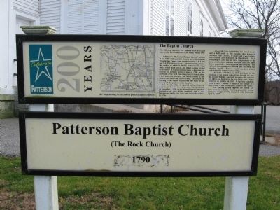
Patterson Baptist Church
Patterson 200 Years
(The Rock Church)
1790
The Baptist Church
The following material was adapted from notes put together by Reverend James B.M. Frost, March 1993:
Pelletreau’s “History of Putnam County,” written in the 1880s indicates that about a half mile from the Triangle Inn Corner (now the intersection of N.Y. 311 and N.Y. 292), there was an “…ancient burying ground, the surface which is studded with rough stones which mark graves …the oldest burying ground in the town.” A Baptist meeting house is shown at that location on Erskin’s military map of 1780, on the north side of the road from Patterson to Carmel, about a half mile west of where Mill Brook crosses it, and about a mile and a half north of here. The date of the building of the church is unknown and there are no records of the pastors or the members.
The church which is reported to have been in existence on that site for many years, was constituted on December 1, 1790, as the Second Baptist Church of Fredrickstown, with thirty members, and it was incorporated under New York State law on September 15, 1794.
About 1812 the old building was moved a mile and a half south to this location, then known as Towner’s Four Corners. It stood until a new building was erected and dedicated in March, 1836. It is interesting to note that all three congregations in the town rebuilt their buildings between 1836 and 1838. It was apparently a time of growth and optimism. The railroad was coming to Patterson and the town was changing rapidly. Towners would soon have both a railroad station and its own Post Office.
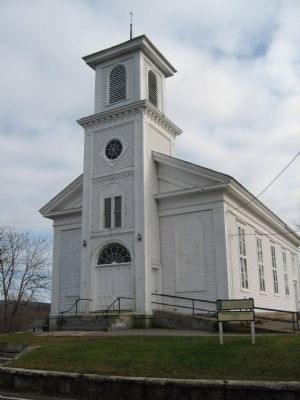
After the Civil War, in 1867, just prior to the extension of the second railroad line through the area, the present building was built to replace the previous one which had been in use for over thirty years. It was dedicated on October 16, 1867. It has been called the “Rock Church” because it stands on the summit of a ridge where a bed of limestone comes to the surface.
The burying ground opposite the church had been used for a family burying ground for several years, but was given to the trustees by John Towner on April 2, 1828.
Topics. This historical marker is listed in this topic list: Churches & Religion. A significant historical month for this entry is March 1993.
Location. 41° 29.242′ N, 73° 37.599′ W. Marker is in Patterson, New York, in Putnam County. Marker is on Route 311, 0.1 miles south of Caroline Drive, on the left when traveling west. Located in front of the Patterson Baptist Church. Touch for map. Marker is at or near this postal address: 595 Route 311, Patterson NY 12563, United States of America. Touch for directions.
Other nearby markers. At least 8 other markers are within 2 miles of this marker, measured as the crow flies. Patterson Veterans Monument (approx. 2 miles away); The War Monument (approx. 2 miles away); District School No. 1 (approx. 2 miles away); Patterson Grange No. 939 (approx. 2 miles away); Christ Church (approx. 2 miles away); Ludington Graves (approx. 2 miles away); The Fellowship Hall (approx. 2 miles away); Maple Avenue Cemetery (approx. 2 miles away). Touch for a list and map of all markers in Patterson.
Also see . . . A Brief History of Patterson Baptist Church. (Submitted on November 30, 2009, by Michael Herrick of Southbury, Connecticut.)
Credits. This page was last revised on June 16, 2016. It was originally submitted on November 30, 2009, by Michael Herrick of Southbury, Connecticut. This page has been viewed 818 times since then and 30 times this year. Photos: 1, 2. submitted on November 30, 2009, by Michael Herrick of Southbury, Connecticut. • Syd Whittle was the editor who published this page.

